Glacial Isostatic Adjustment
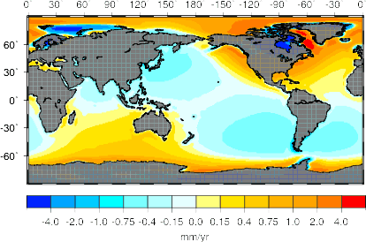
On a global basis, glacial isostatic adjustment (GIA) is one of the most modelled of the geophysical signal present in tide gauge data. The plot to the right shows Prof. Richard Peltier's prediction for tide gauge rates from the one degree resolution, ICE-5G (VM2) solutions given below. This map shows a number of features of GIA predictions for relative sea level (RSL; the sea level as measured by tide gauges) rates, and the colour bar was chosen to highlight far field features.
Near the loading centres, RSL is falling due to the continued uplift of the crust. Surrounding these loading centres, the crust is subsiding due to the collapse of forebulge, and thus RSL is increasing. However, RSL is also impacted by changes to the sea surface. Thus, correction for crustal motion (e.g., through GPS uplift estimates) only partially removes the impacts due to GIA. The Moving Boundaries of Sea Level Change: Understanding the Origins of Geographic Variability, by Mark Tamisiea and Jerry Mitrovica in a special issue of Oceanography adressing sea level, gives a general overview of the effects of GIA on present-day sea level measurements.
GIA models are available from several scientists:
- Prof. Richard Peltier (University of Toronto) has made available his ICE-5G (VM2) and ICE-5G (VM4) relative sea level predictions.
- Prof. Jerry Mitrovica (Harvard University).
- Other scientist include Prof. Kurt Lambeck (Australian National University), Prof. Roberto Sabadini (University of Milan) and Prof. John Wahr (University of Colorado).
Illustrations of the evolution of the shorelines over the last 20,000 years is shown in this set of results from the Proudman Oceanographic Laboratories and the Universities of Durham and Toronto.

![]()
![]()
![]()
