Data
- Obtaining
- Supplying
- High-Frequency
- Bottom Pressure Records
- Other Long Records
- GLOSS/ODINAFRICA Calibration Data
Donate
Donate to PSMSL
Data Notes
- Individual Station Data and Plot Notes
- Referencing the Data Set
- PSMSL Help File
- 2010 Changes to the PSMSL Data Files
Extracted from Database
20 Jul 2026
Station Information
| Station ID: | 1591 |
| Latitude: | 3.05 |
| Longitude: | 101.358333 |
| Coastline code: | 550 |
| Station code: | 7 |
| Country: | MALAYSIA |
| Time span of data: | 1984 – 2018 |
| Completeness (%): | 90 |
| Date of last update: | 11 Sep 2019 |
| Green Arrow: | Current Station |
| Yellow Marker: | Neighbouring RLR Station |
| Red Marker: | Neighbouring Metric Station |
Please note: In many cases, the station position in our database is accurate to only one minute. Thus, the tide gauge may not appear to be on the coast.
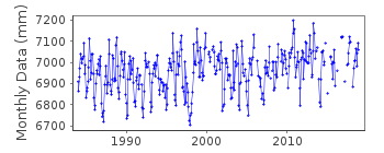
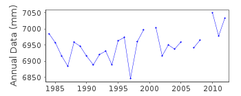
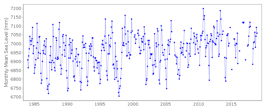
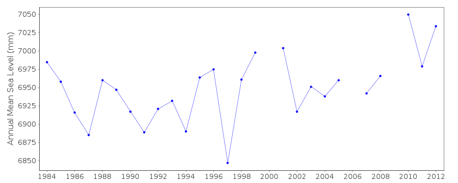
Tide Gauge Data
Additional Data Sources (guide to additional data sources)
Research Quality Data from UHSLC station 140: hourly and dailyStation Documentation
Link to RLR information.Documentation added 1991-06-11
Port Kelang 550/007 RLR(1984) is 10.8m below BM No B0169Documentation added 1993-07-12
Port Kelang 550/007 RLR(1984) is 10.8m below BM No B0169Documentation added 1995-07-13
13 October 1993: tide gauge replacedDocumentation added 2012-09-17
Publication Tidal Observation Records 2010 confirms Primary benchmark remainsBM B0169 7.494m above TGZ.
Data Authority
Department of Survey and MappingWisma JUPEM
Jalan Semarak
50578 Kuala Lumpur

![]()
![]()
![]()
