Data
- Obtaining
- Supplying
- High-Frequency
- Bottom Pressure Records
- Other Long Records
- GLOSS/ODINAFRICA Calibration Data
Donate
Donate to PSMSL
Data Notes
- Individual Station Data and Plot Notes
- Referencing the Data Set
- PSMSL Help File
- 2010 Changes to the PSMSL Data Files
Extracted from Database
11 May 2026
Station Information
| Station ID: | 959 |
| Latitude: | 35.983333 |
| Longitude: | 126.716667 |
| Coastline code: | 620 |
| Station code: | 21 |
| Country: | KOREA, REPUBLIC OF |
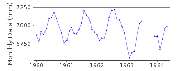
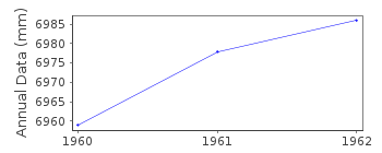
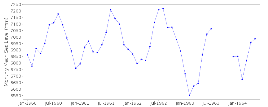
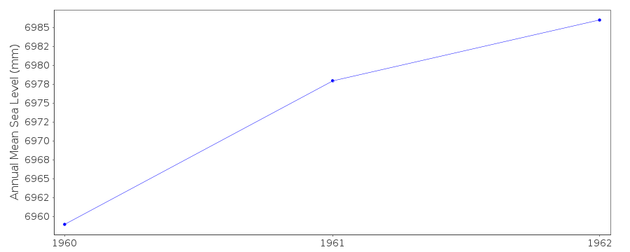
| Time span of RLR data: | 1960 – 1964 |
| RLR completeness (%): | 82 |
| Time span of metric data: | 1960 – 1999 |
| Metric completeness (%): | 20 |
| Date of last update: | 25 Jan 2001 |
| Green Arrow: | Current Station |
| Yellow Marker: | Neighbouring RLR Station |
| Red Marker: | Neighbouring Metric Station |
Please note: In many cases, the station position in our database is accurate to only one minute. Thus, the tide gauge may not appear to be on the coast.
Tide Gauge Data
Station Documentation
Link to RLR information.Documentation added 1991-06-11
Kunsan 620/021 RLR(1962) is 11.2m below TBMDocumentation added 1993-07-12
Kunsan 620/021 RLR(1962) is 11.2m below TBMKunsan is an historic station last data 1964
This station was replaced by Gunsan (Outer Port)
Data Authority
Korea Hydrographic and Oceanographic Agency (KHOA)351, Haeyang-ro
Yeongdo-gu
Busan
Republic of Korea
Documentation added 2000-10-11
The National Oceanographic Research Institute of Korea wasformerly (pre late-1990s) the Office of Hydrographic Affairs
(same address).
Documentation added 2018-05-17
KHOA was formerly the National Oceanographic Research Institute

![]()
![]()
![]()
