Data
- Obtaining
- Supplying
- High-Frequency
- Bottom Pressure Records
- Other Long Records
- GLOSS/ODINAFRICA Calibration Data
Donate
Donate to PSMSL
Data Notes
- Individual Station Data and Plot Notes
- Referencing the Data Set
- PSMSL Help File
- 2010 Changes to the PSMSL Data Files
Extracted from Database
11 Mar 2024
Station Information
| Station ID: | 952 |
| Latitude: | 35.633333 |
| Longitude: | 139.75 |
| Coastline code: | 642 |
| Station code: | 72 |
| Country: | JAPAN |
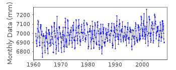
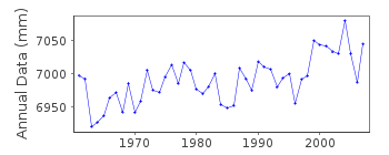
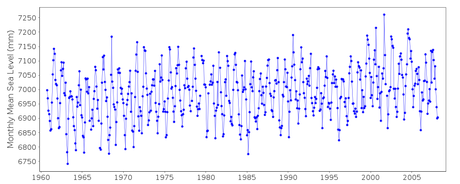
| Time span of data: | 1960 – 2008 |
| Completeness (%): | 96 |
| Date of last update: | 20 Apr 2009 |
| Green Arrow: | Current Station |
| Yellow Marker: | Neighbouring RLR Station |
| Red Marker: | Neighbouring Metric Station |
Please note: In many cases, the station position in our database is accurate to only one minute. Thus, the tide gauge may not appear to be on the coast.
Tide Gauge Data
Station Documentation
Link to RLR information.Documentation added 1991-06-11
Sibaura 642/072 RLR(1972) is 9.7m below BM SibauraThere is some confusion on the original RLR diagram on this diagram data 1961-1963 has a BM?TGZ of 5.119m. However, there is a comment that data 1960- has a BM/TGZ value of 4.531 in pub.no.793 of Nov 1965. RLRFAC has not been adjusted until the data for 1985- where the BM/TGZ is given as 4.519m
Data Authority
Japan Oceanographic Data CentreHydrographic Department, Maritime Safety Agency
MLIT Aomi Building
2-5-18, Aomi, Koto-ku
Tokyo 135-0064

![]()
![]()
![]()
