Data
- Obtaining
- Supplying
- High-Frequency
- Bottom Pressure Records
- Other Long Records
- GLOSS/ODINAFRICA Calibration Data
Donate
Donate to PSMSL
Data Notes
- Individual Station Data and Plot Notes
- Referencing the Data Set
- PSMSL Help File
- 2010 Changes to the PSMSL Data Files
Extracted from Database
09 Feb 2026
Station Information
| Station ID: | 832 |
| Latitude: | -34.566667 |
| Longitude: | -58.4 |
| Coastline code: | 860 |
| Station code: | 161 |
| Country: | ARGENTINA |
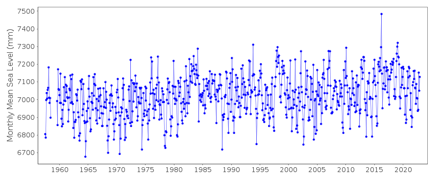
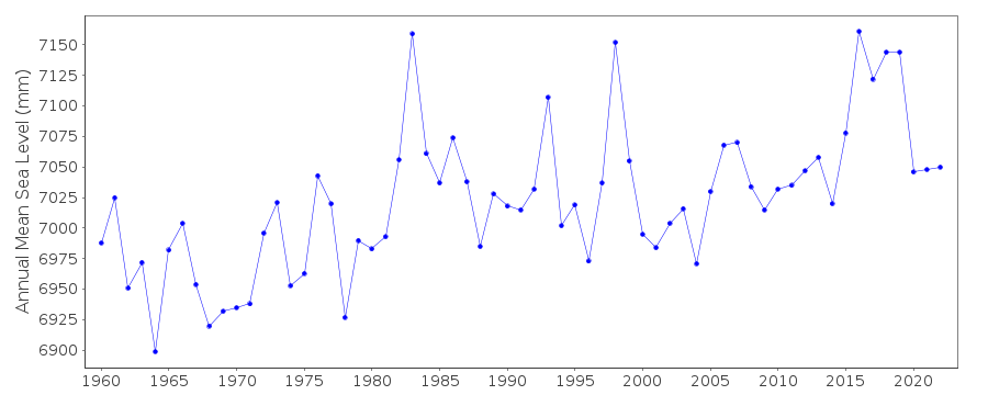
| Time span of data: | 1957 – 2022 |
| Completeness (%): | 98 |
| Date of last update: | 03 Jan 2024 |
| Green Arrow: | Current Station |
| Yellow Marker: | Neighbouring RLR Station |
| Red Marker: | Neighbouring Metric Station |
Please note: In many cases, the station position in our database is accurate to only one minute. Thus, the tide gauge may not appear to be on the coast.
Tide Gauge Data
Additional Data Sources (guide to additional data sources)
Nearby GNSS Stations from SONEL: BUE2, BUE1, IGM1, MA02Station Documentation
Link to RLR information.Documentation - date unknown
Noticeable meteorological influencesDocumentation added 1991-06-11
Palermo 860/161 RLR(1977) is 11.4m below Pilar SHN No 1Documentation added 1993-10-01
End of 1982 and into 1983 flooding occurred in basins of Parana and Urugay rivers. June 1988 unusually strong winds which decreased the height of the astronomic tide causing an unusual low value for MSL.Data Authority
Servicio de Hidrografia NavalDepartmento Oceanografia
Av. Montes de Oca 2124
1271 Buenos Aires

![]()
![]()
![]()
