Data
- Obtaining
- Supplying
- High-Frequency
- Bottom Pressure Records
- Other Long Records
- GLOSS/ODINAFRICA Calibration Data
Donate
Donate to PSMSL
Data Notes
- Individual Station Data and Plot Notes
- Referencing the Data Set
- PSMSL Help File
- 2010 Changes to the PSMSL Data Files
Extracted from Database
08 Dec 2025
Station Information
| Station ID: | 823 |
| Latitude: | 21.431667 |
| Longitude: | -157.79 |
| Coastline code: | 760 |
| Station code: | 41 |
| Country: | UNITED STATES |
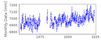
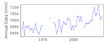
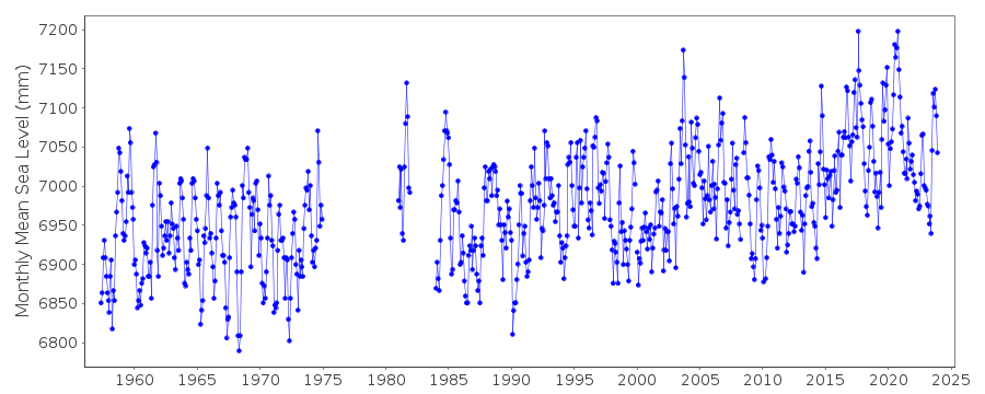
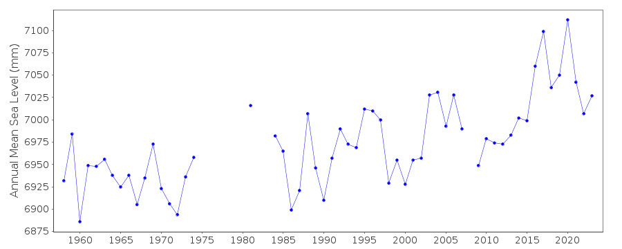
| Time span of data: | 1957 – 2023 |
| Completeness (%): | 87 |
| Date of last update: | 26 Jan 2024 |
| Green Arrow: | Current Station |
| Yellow Marker: | Neighbouring RLR Station |
| Red Marker: | Neighbouring Metric Station |
Please note: In many cases, the station position in our database is accurate to only one minute. Thus, the tide gauge may not appear to be on the coast.
Tide Gauge Data
Additional Data Sources (guide to additional data sources)
Nearby Real Time Stations from VLIZ: heeia, mokuFast Delivery Data from UHSLC station 423: hourly and daily
Fast Delivery Data from UHSLC station 61: hourly and daily
Research Quality Data from UHSLC station 61: hourly and daily
Station Documentation
Link to RLR information.Documentation - date unknown
Data prior to 1970 based on 24 redaings per dayDocumentation added 1991-06-11
Mokuoloe Island 760/041 RLR(1969) is 8.4m below BM7Documentation added 2011-11-24
Using information from the NOAA website the RLR diagram has been revised. Primary benchmark is now NO 1 1957 1.969m above gauge datum. This benchmark appears on the original RLR diagram as a secondary benchmark with the same value. Previous Primary benchmark NO 7 1968 is included in the NOAA report for 2000 with a value of 2.657m relative to the gauge datum but does not appear in the NOAA report of 2003.Data Authority
N.O.A.A. / N.O.S.N/oes33, Ssmc4, Room 6531
1305 East-West Highway
Silver Spring,
MD 20910

![]()
![]()
![]()
