Data
- Obtaining
- Supplying
- High-Frequency
- Bottom Pressure Records
- Other Long Records
- GLOSS/ODINAFRICA Calibration Data
Donate
Donate to PSMSL
Data Notes
- Individual Station Data and Plot Notes
- Referencing the Data Set
- PSMSL Help File
- 2010 Changes to the PSMSL Data Files
Extracted from Database
06 Apr 2026
Station Information
| Station ID: | 818 |
| Latitude: | -31.516667 |
| Longitude: | 159.066667 |
| GLOSS ID: | 148 |
| Coastline code: | 680 |
| Station code: | 121 |
| Country: | AUSTRALIA |
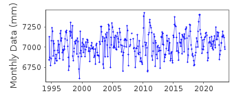
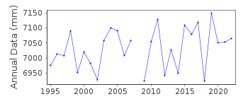
| Time span of RLR data: | 1994 – 2023 |
| RLR completeness (%): | 97 |
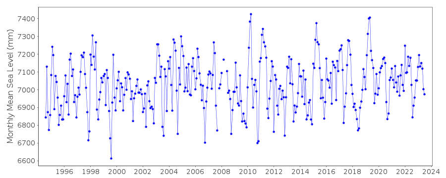
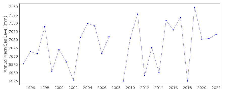
| Time span of metric data: | 1957 – 2023 |
| Metric completeness (%): | 71 |
| MTL Data: | 1957 |
| MTL-MSL (mm): | -4 |
| Date of last update: | 20 Mar 2025 |
| Green Arrow: | Current Station |
| Yellow Marker: | Neighbouring RLR Station |
| Red Marker: | Neighbouring Metric Station |
Please note: In many cases, the station position in our database is accurate to only one minute. Thus, the tide gauge may not appear to be on the coast.
Tide Gauge Data
Additional Data Sources (guide to additional data sources)
Nearby GNSS Stations from SONEL: LDHI, LORDFast Delivery Data from UHSLC station 399: hourly and daily
Research Quality Data from UHSLC station 399: hourly and daily
Station Documentation
Link to RLR information.Documentation added 1995-05-02
Station density along some sections of the Australian coast has meant that station codes 601 onwards have been re-ordered compared to those in earlier versions of the PSMSL data set.Documentation added 1996-05-03
1957 values based on high and low waters. Revised data for 1958-1970 data received from the National Tidal Centre, Bureau of Meteorology, South AustraliaDocumentation added 1998-01-27
Gauge type=float/stilling well digital float/stilling well installed in 1991Documentation added 2010-08-24
Metadata received from supplying authority confirms that from August 1994, vertical reference frame of data is AHD (Australian Height Datum). Local tide gauge benchmark PSM 1084 is 7.68 m above AHD. RLR (2006) is defined as 13.6 m below PSM 1084Documentation added 2016-01-22
A value of MTL-MSL=-4 mm has been derived using the GESLA2 (high-frequency tide gauge) dataset using harmonic constituents. As the correction is only applied to RLR data and the data from the year 1957 is metric, it is not used in the data set. Should this period become metric in future, however, it would be used.Data Authority
National Tidal CentreBureau of Meteorology
PO Box 421
Kent Town 5071
South Australia
Documentation added 2010-08-12
Formerly known as the National Tidal Facility

![]()
![]()
![]()
