Data
- Obtaining
- Supplying
- High-Frequency
- Bottom Pressure Records
- Other Long Records
- GLOSS/ODINAFRICA Calibration Data
Donate
Donate to PSMSL
Data Notes
- Individual Station Data and Plot Notes
- Referencing the Data Set
- PSMSL Help File
- 2010 Changes to the PSMSL Data Files
Extracted from Database
11 Mar 2024
Station Information
| Station ID: | 79 |
| Latitude: | 65.040317 |
| Longitude: | 25.418233 |
| Coastline code: | 60 |
| Station code: | 11 |
| Country: | FINLAND |
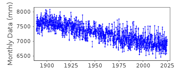
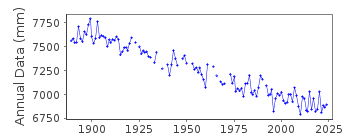
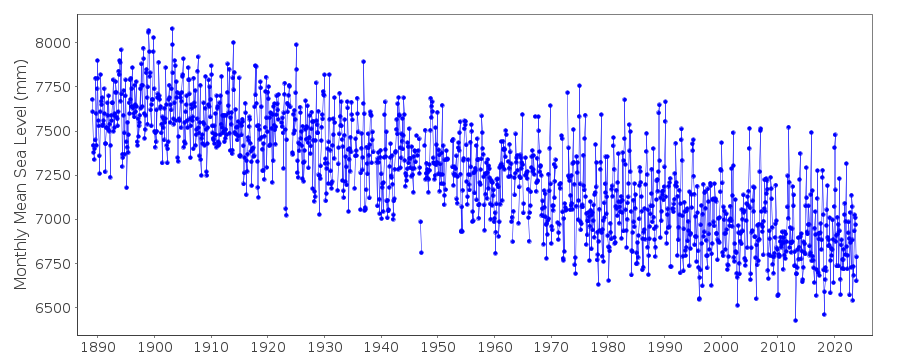
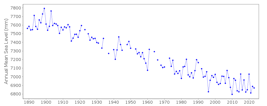
| Time span of data: | 1889 – 2023 |
| Completeness (%): | 96 |
| Date of last update: | 05 Mar 2024 |
| Green Arrow: | Current Station |
| Yellow Marker: | Neighbouring RLR Station |
| Red Marker: | Neighbouring Metric Station |
Please note: In many cases, the station position in our database is accurate to only one minute. Thus, the tide gauge may not appear to be on the coast.
Tide Gauge Data
Additional Data Sources (guide to additional data sources)
Nearby GNSS Stations from SONEL: OUL2, OULUStation Documentation
Link to RLR information.Documentation added 1991-06-11
Oulu/Uleaborg 060/011 RLR(1964) is 9.7m below BM116Documentation added 1998-07-21
21 July 1998: RLR redefined following review of data revisionsDocumentation added 2002-09-24
A description of the sea level network in Finland can be found in 'Operational Oceanography: Implementation at the European and Regional scales. 2002 (pp.129-137)'.1889-1921 VALUES BASED ON 1 READING PER DAY
1922-1970 VALUES BASED ON 6 READINGS PER DAY
Documentation added 2012-01-09
Levelling information recently supplied by the Finnish Meteorological Institute confirms that the Primary benchmark remains 116 4.231m above the datum for 1913 onwards. This also brought attention to a previous error in the documentation. The relationship between BM 116 and RLR was quoted as being 9.5m when infact it should be 9.7m.Documentation added 2017-05-04
Primary benchmark is now TGBM 04006 as the previous Primary benchmark TGBM 116 was destoyed during construction work.Documentation added 2019-11-27
From 2018 onwards the averages of the Finnish sea level data will be based on 1 min observations. Values are calculated in Finnish normal time (EET).The data are relative to the reference surface of the Finnish sea level observations and thus the datum is the tide gauge zero.
Data Authority
Finnish Meteorological InstituteMarine Research, Waves and Sea Level
Erik Palenin aukio 1
P.O. Box 503
FI - 00101 Helsinki

![]()
![]()
![]()
