Data
- Obtaining
- Supplying
- High-Frequency
- Bottom Pressure Records
- Other Long Records
- GLOSS/ODINAFRICA Calibration Data
Donate
Donate to PSMSL
Data Notes
- Individual Station Data and Plot Notes
- Referencing the Data Set
- PSMSL Help File
- 2010 Changes to the PSMSL Data Files
Extracted from Database
11 Mar 2024
Station Information
| Station ID: | 777 |
| Latitude: | 13.916667 |
| Longitude: | -90.816667 |
| Coastline code: | 832 |
| Station code: | 12 |
| Country: | GUATEMALA |
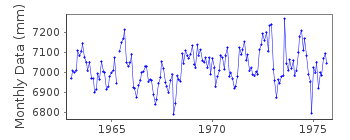
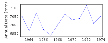
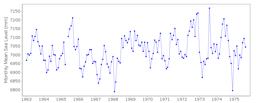
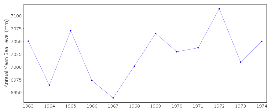
| Time span of RLR data: | 1963 – 1975 |
| RLR completeness (%): | 97 |
| Time span of metric data: | 1955 – 1975 |
| Metric completeness (%): | 95 |
| Date of last update: | 03 Dec 1997 |
| Green Arrow: | Current Station |
| Yellow Marker: | Neighbouring RLR Station |
| Red Marker: | Neighbouring Metric Station |
Please note: In many cases, the station position in our database is accurate to only one minute. Thus, the tide gauge may not appear to be on the coast.
Tide Gauge Data
Additional Data Sources (guide to additional data sources)
Nearby Real Time Stations from VLIZ: prsjResearch Quality Data from UHSLC station 675: hourly and daily
Research Quality Data from UHSLC station 301: hourly and daily
Station Documentation
Link to RLR information.Documentation added 1991-06-11
San Jose II 832/012 RLR(1973) is 12.3m below BMDocumentation added 1997-11-14
data for 1955-62 received from the University of Hawaii Sea Level Center Instrument type: standard float and well gaugeDocumentation added 2012-10-04
San Jose II is an historic station last data 1975.Data Authority
Insivumeh7a Avenida 14-57
Zona 13

![]()
![]()
![]()
