Data
- Obtaining
- Supplying
- High-Frequency
- Bottom Pressure Records
- Other Long Records
- GLOSS/ODINAFRICA Calibration Data
Donate
Donate to PSMSL
Data Notes
- Individual Station Data and Plot Notes
- Referencing the Data Set
- PSMSL Help File
- 2010 Changes to the PSMSL Data Files
Extracted from Database
26 Jan 2026
Station Information
| Station ID: | 764 |
| Latitude: | -34.65 |
| Longitude: | -54.15 |
| Coastline code: | 870 |
| Station code: | 31 |
| Country: | URUGUAY |
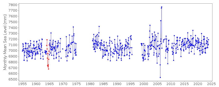
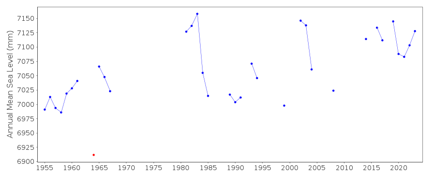
| Time span of data: | 1955 – 2024 |
| Completeness (%): | 73 |
| Date of last update: | 09 May 2025 |
| Green Arrow: | Current Station |
| Yellow Marker: | Neighbouring RLR Station |
| Red Marker: | Neighbouring Metric Station |
Please note: In many cases, the station position in our database is accurate to only one minute. Thus, the tide gauge may not appear to be on the coast.
Tide Gauge Data
Station Documentation
Link to RLR information.Documentation added 1991-06-11
La Paloma 870/031 RLR(1967) is 10.9m below BM SH10Documentation added 1994-07-12
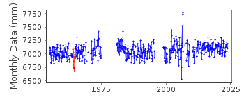
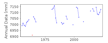
Anomalously low values for April-October 1964 correct as received from authority.Data Authority
SOHMA (Oceanographic, Hydrography andMeteorology Service of the Uruguayan Navy)
Capurro 980
MONTEVIDEO

![]()
![]()
![]()
