Data
- Obtaining
- Supplying
- High-Frequency
- Bottom Pressure Records
- Other Long Records
- GLOSS/ODINAFRICA Calibration Data
Donate
Donate to PSMSL
Data Notes
- Individual Station Data and Plot Notes
- Referencing the Data Set
- PSMSL Help File
- 2010 Changes to the PSMSL Data Files
Extracted from Database
11 Mar 2024
WARNING: QCFLAG EXISTS. PLEASE READ THE DOCUMENTATION.
Station Information
| Station ID: | 752 |
| Latitude: | 38.563333 |
| Longitude: | 139.545833 |
| Coastline code: | 647 |
| Station code: | 91 |
| Country: | JAPAN |
| Time span of data: | 1955 – 2023 |
| Completeness (%): | 92 |
| Link to ellipsoid: | Available |
| Date of last update: | 04 Mar 2024 |
| Green Arrow: | Current Station |
| Yellow Marker: | Neighbouring RLR Station |
| Red Marker: | Neighbouring Metric Station |
Please note: In many cases, the station position in our database is accurate to only one minute. Thus, the tide gauge may not appear to be on the coast.
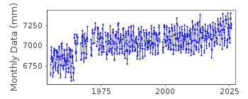
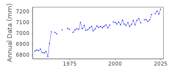
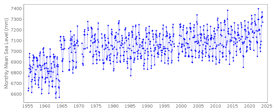
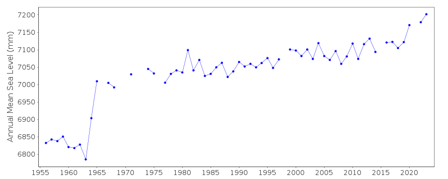
Tide Gauge Data
Station Documentation
Link to RLR information.Documentation - date unknown
Ground depression about 18cm accompanied the Niigata earthquake of June 16,1964Documentation added 1991-06-11
Nezugaseki 647/091 RLR(1975) is 9.3m below BM Attach-16Documentation added 2011-02-23
Buddy checked with Awa Sima. Profiles compare well particularly from the 1980's onwards. From May 1980 the benchmark still called Attached-16 but with a height of 8.961m above the datum was used. On the diagram this has been labelled Attach-16 (ii)Documentation added 2012-02-21
A massive earthquake magnitude 9.0 occurred at 14.46 JST (05.46 UTC) on Friday 11th March 2011 with the epicentre approx. 70km east of the Oshika Peninsula of TTohoku. It was the most powerful known earthquake to hit Japan triggering a tsunami with waves up to 40.5m and travelling up to 10km inland.Documentation added 2014-03-13
The GPS benchmark information has been downloaded from the SONEL website. GPS benchmark is P105 13.017m above RLR.Data Authority
Geographical Survey InstituteKitasato -1
Tsukuba-shi
Ibaraki-ken 305

![]()
![]()
![]()
