Data
- Obtaining
- Supplying
- High-Frequency
- Bottom Pressure Records
- Other Long Records
- GLOSS/ODINAFRICA Calibration Data
Donate
Donate to PSMSL
Data Notes
- Individual Station Data and Plot Notes
- Referencing the Data Set
- PSMSL Help File
- 2010 Changes to the PSMSL Data Files
Extracted from Database
02 Mar 2026
Station Information
| Station ID: | 686 |
| Latitude: | 16.833333 |
| Longitude: | -99.916667 |
| GLOSS ID: | 267 |
| Coastline code: | 830 |
| Station code: | 81 |
| Country: | MEXICO |
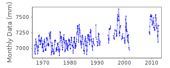
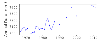
| Time span of RLR data: | 1967 – 2012 |
| RLR completeness (%): | 70 |
| Time span of metric data: | 1952 – 2012 |
| Metric completeness (%): | 77 |
| Date of last update: | 24 Jun 2015 |
| Green Arrow: | Current Station |
| Yellow Marker: | Neighbouring RLR Station |
| Red Marker: | Neighbouring Metric Station |
Please note: In many cases, the station position in our database is accurate to only one minute. Thus, the tide gauge may not appear to be on the coast.
Tide Gauge Data
Additional Data Sources (guide to additional data sources)
Nearby GNSS Stations from SONEL: ACYANearby Real Time Stations from VLIZ: acya
Fast Delivery Data from UHSLC station 316: hourly and daily
Research Quality Data from UHSLC station 316: hourly and daily
Station Documentation
Link to RLR information.Documentation added 1991-06-11
Acapulco 830/081 RLR(1964) is 9.1m below BM1Documentation added 1992-01-16
Gauge at new site from July 1972Documentation added 1996-10-10
Data for 1991 and 1994 received from UHSLC 1992-93 data not included because of poor quality UHSLC report a level shift of about -15cm on 11 May 1962 instrument type: standard gauge with float and stilling wellDocumentation added 1997-01-30
Large earthquake offshore of Mexico about 19 degrees North on 9 October 1995 with large tsunami generated. See article by A.E.Filonov in EOS, 78(3), 1997.Documentation added 2002-09-26
Earthquakes may have affected the Acapulco record with a sea level fall of order 300 mm in 1962. Another earthquake occurred in 1995 (source Dr. Osvaldo Sanchez, Inst. de Geofisica, 2002).Documentation added 2015-06-24
Levelling information has now been received from UNAM Mexico. Primary benchmark is now BM 1B 2.529m above TGZ. The TGZ has not changed.Data Authority
Servicio Mareografico NacionalInstituto de Geofisica, Ciudad Universitaria
Delegacion de Coyoacan
04510 Mexico D.F.

![]()
![]()
![]()
