Data
- Obtaining
- Supplying
- High-Frequency
- Bottom Pressure Records
- Other Long Records
- GLOSS/ODINAFRICA Calibration Data
Donate
Donate to PSMSL
Data Notes
- Individual Station Data and Plot Notes
- Referencing the Data Set
- PSMSL Help File
- 2010 Changes to the PSMSL Data Files
Extracted from Database
11 Mar 2024
WARNING: QCFLAG EXISTS. PLEASE READ THE DOCUMENTATION.
Station Information
| Station ID: | 670 |
| Latitude: | 38.1 |
| Longitude: | 15.65 |
| Coastline code: | 250 |
| Station code: | 61 |
| Country: | ITALY |
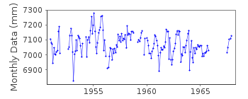
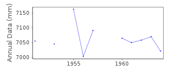
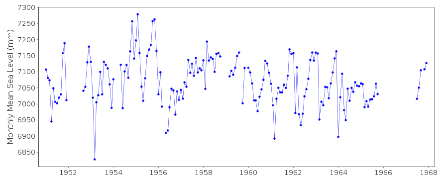
| Time span of data: | 1951 – 1967 |
| Completeness (%): | 81 |
| Date of last update: | 01 Jan 1980 |
| Green Arrow: | Current Station |
| Yellow Marker: | Neighbouring RLR Station |
| Red Marker: | Neighbouring Metric Station |
Please note: In many cases, the station position in our database is accurate to only one minute. Thus, the tide gauge may not appear to be on the coast.
Tide Gauge Data
Additional Data Sources (guide to additional data sources)
Nearby GNSS Stations from SONEL: TGRCNearby Real Time Stations from VLIZ: RC09
Station Documentation
Link to RLR information.Documentation added 1991-06-11
Reggio Calabria 250/061 RLR(1964) is 9.5m below BMDocumentation added 1992-08-06
Italian levels may be infuenced by the Messina earthquake of 1908 - see Bottari et al., tectonophysics, 202, 269-275, 1992Documentation added 1993-03-17
The stations Porto Maurizio (250/001), Napoli Arsenale (250/041) and Napoli Mandraccio (250/051) appear to each have a datum shift around 1910. Evidence for regional coherence?Documentation added 1993-07-30
Not a good looking record - evidence for several datum shifts. Reggio Calabria is an historic station. Last data 1967Documentation added 1998-12-07
For a discussion of land movements in the area of the Gulf of Naples, see the paper by G.Berrino in Tectonophysics,294,323-332,1998. NO BM INFORMATION BUT DATA SEEMS HOMOGENEOUSData Authority
CNR - Istituto di Scienze MarineAREA Science Park
Basovizza
I-34149 Trieste
Documentation added 2008-10-31
This authority was formerly called the Istituto Talassograficodi Trieste.

![]()
![]()
![]()
