Data
- Obtaining
- Supplying
- High-Frequency
- Bottom Pressure Records
- Other Long Records
- GLOSS/ODINAFRICA Calibration Data
Donate
Donate to PSMSL
Data Notes
- Individual Station Data and Plot Notes
- Referencing the Data Set
- PSMSL Help File
- 2010 Changes to the PSMSL Data Files
Extracted from Database
11 Mar 2024
Station Information
| Station ID: | 668 |
| Latitude: | 8.266667 |
| Longitude: | -82.866667 |
| Coastline code: | 840 |
| Station code: | 1 |
| Country: | PANAMA |
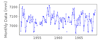
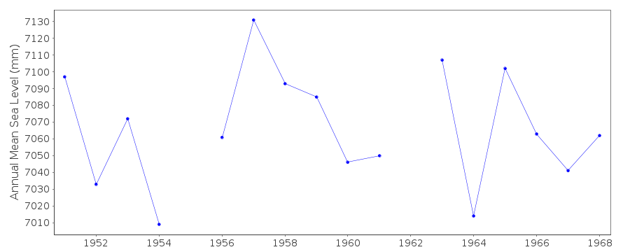
| Time span of data: | 1951 – 1968 |
| Completeness (%): | 94 |
| Date of last update: | 01 Jan 1980 |
| Green Arrow: | Current Station |
| Yellow Marker: | Neighbouring RLR Station |
| Red Marker: | Neighbouring Metric Station |
Please note: In many cases, the station position in our database is accurate to only one minute. Thus, the tide gauge may not appear to be on the coast.
Tide Gauge Data

Additional Data Sources (guide to additional data sources)
Nearby GNSS Stations from SONEL: PUARResearch Quality Data from UHSLC station 304: hourly and daily
Station Documentation
Link to RLR information.Documentation added 1991-06-11
Puerto Armuelles 840/001 RLR(1964) is 12.6m below BM3Documentation added 1995-09-08
The sea level difference either side of the Panama Canal is approx. 20 cm (higher on the Pacific side) - see for example, Pugh, D.T. 1987, "Tides, surges and mean sea-level", Wiley. RLR 1964 datum at Balboa is 3.112 m below the "Tide Staff Zero" which is itself 12 feet below Panama Canal Precise Level Datum (PLD). On the Atlantic side, at Coco Solo RLR 1993 is 6.288 m below the Tide Staff Zero which is itself 2 feet below PLD there. For the older Cristobal data, RLR 1964 is 6.138 m below the Tide Staff Zero which is itself 2 feet below PLD. From inspection of RLR data and from this information, one can indeed verify that sea level is higher on the Pacific side by about 20 cm. However, the accuracy of the PLD national levellingsystem is unclear. Data prior to 1984 supplied by NOAA
Documentation added 1996-02-26
Data 1983 and since 1992 received from TOGA officeDocumentation added 1996-10-09
Gauge type=standard mechanical float and well gaugeDocumentation added 2002-10-31
Puerto Armuelles - correction factor (RLRFAC) 1983- calculated from correspondance 19/10/92.Documentation added 2003-02-27
Data after 1968 has been moved to a new data series, Puerto Armuelles B (840/002), since it has not been possible to link the two series together with a common datum.Data Authority
Instituto Geografico NacionalTommy Guardia
Apartado 5267
Panama 5

![]()
![]()
![]()
