Data
- Obtaining
- Supplying
- High-Frequency
- Bottom Pressure Records
- Other Long Records
- GLOSS/ODINAFRICA Calibration Data
Donate
Donate to PSMSL
Data Notes
- Individual Station Data and Plot Notes
- Referencing the Data Set
- PSMSL Help File
- 2010 Changes to the PSMSL Data Files
Extracted from Database
01 Jun 2026
Station Information
| Station ID: | 65 |
| Latitude: | -33.85 |
| Longitude: | 151.233333 |
| GLOSS ID: | 57 |
| Coastline code: | 680 |
| Station code: | 141 |
| Country: | AUSTRALIA |
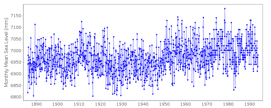
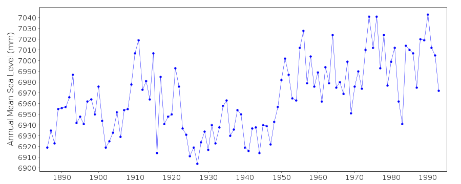
| Time span of data: | 1886 – 1993 |
| Completeness (%): | 100 |
| Date of last update: | 10 May 2000 |
| Green Arrow: | Current Station |
| Yellow Marker: | Neighbouring RLR Station |
| Red Marker: | Neighbouring Metric Station |
Please note: In many cases, the station position in our database is accurate to only one minute. Thus, the tide gauge may not appear to be on the coast.
Tide Gauge Data
Additional Data Sources (guide to additional data sources)
Nearby GNSS Stations from SONEL: CHIP, SYDN, UNSW, FTDNFast Delivery Data from UHSLC station 333: hourly and daily
Research Quality Data from UHSLC station 333: hourly and daily
Station Documentation
Link to RLR information.Documentation added 1991-06-11
Sydney, F.Denison 680/141 RLR(1972) is 12.7m below PM 101Documentation added 1993-07-12
Sydney, F.Denison 680/141 RLR(1972) is 12.7m below PM 101Documentation added 1995-05-02
station density along some sections of the Australian coasthas meant that station codes 601 onwards have been reordered
compared to those in earlier versions of the PSMSL data set.
Documentation added 2000-05-10
Data from this Fort Denison record were obtained from authority 93 upuntil 1993. Data are MTL (high and low waters). Values for 1914 and
earlier are taken from a recomputation of the data by B.V.Hamon,
'A century of tide records: Sydney (Fort Denison) 1886-1986',
Flinders Institute for Atmospheric and Marine Sciences Technical
Report No.7, July 1987.
Later data from Fort Denison can be found in other PSMSL records and
are MSL, based on data from a new tide gauge.
Documentation added 2000-05-10
Note that Hamon estimated MSL-MTL to be only 1.7 mm at Fort Denison.Sydney, Fort Denison is an historic station last data 1993
Data Authority
Maritime Services Board of N.S.W.Box 32 G.P.O.
Sydney
N.S.W. 2001

![]()
![]()
![]()
