Data
- Obtaining
- Supplying
- High-Frequency
- Bottom Pressure Records
- Other Long Records
- GLOSS/ODINAFRICA Calibration Data
Donate
Donate to PSMSL
Data Notes
- Individual Station Data and Plot Notes
- Referencing the Data Set
- PSMSL Help File
- 2010 Changes to the PSMSL Data Files
Extracted from Database
09 Feb 2026
Station Information
| Station ID: | 634 |
| Latitude: | 35.348475 |
| Longitude: | 25.152692 |
| Coastline code: | 290 |
| Station code: | 101 |
| Country: | GREECE |
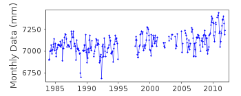
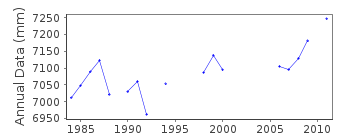
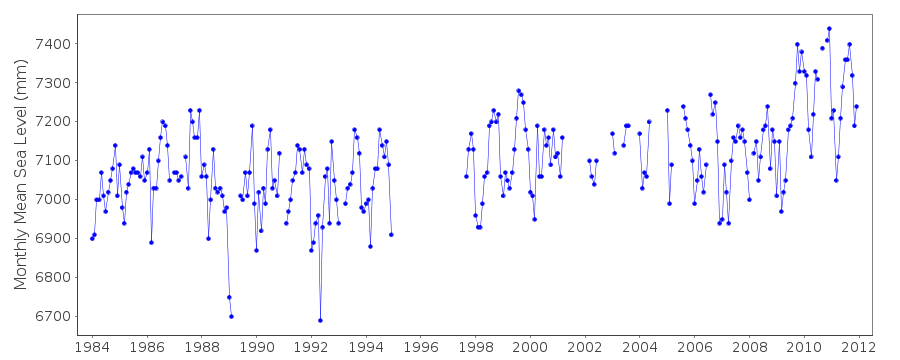
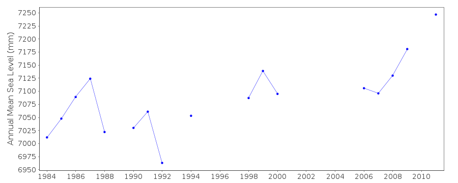
| Time span of RLR data: | 1984 – 2011 |
| RLR completeness (%): | 76 |
| Time span of metric data: | 1951 – 2011 |
| Metric completeness (%): | 44 |
| Date of last update: | 18 Jul 2013 |
| Green Arrow: | Current Station |
| Yellow Marker: | Neighbouring RLR Station |
| Red Marker: | Neighbouring Metric Station |
Please note: In many cases, the station position in our database is accurate to only one minute. Thus, the tide gauge may not appear to be on the coast.
Tide Gauge Data
Additional Data Sources (guide to additional data sources)
Nearby GNSS Stations from SONEL: HERANearby Real Time Stations from VLIZ: hrak
Station Documentation
Link to RLR information.Documentation added 1997-03-11
The contributing authority advises that anomalous values are the result of met. influencesDocumentation added 2000-04-25
Iraklion 290/101 RLR(1988) is 8.7m below BM R ADocumentation added 2011-03-03
Because of the unresolved datum problem at Iraklion from when the sea level measurement was revised from measuring downwards to measuring the more conventional method of upwards the station has been flagged.The process adopted is that the station remains RLR so that the RLR data is still visible on the database up to the change in March 2002. From March 2002 thedata reverts to being Metric. Previously data labelled Metric for the period Jan 1989-December 1997 has been upgraded to RLR status as there seems no reason for it to remain Metric. There is a gap in the data January 1995-August 1996.
Documentation added 2011-07-13
Following further information from the Hellenic Navy Ocranography Service an adjustment has been made to the data. The plotted data now appears to be correct. Therefore the station flag has been removed and the data once again reinstated to RLR status. The RLR diagram has also been updated.Documentation added 2013-03-14
Following datum diagrams supplied by the Hellenic Navy the RLR factors have been changed. Iraklion tide gauge was moved in September 2009. This station has been superceded by Iraklion II id. 2165Data Authority
Hellenic Navy Hydrographic ServiceGeographic Policy and International Relations Office
TGN 1040
Athens

![]()
![]()
![]()
