Data
- Obtaining
- Supplying
- High-Frequency
- Bottom Pressure Records
- Other Long Records
- GLOSS/ODINAFRICA Calibration Data
Donate
Donate to PSMSL
Data Notes
- Individual Station Data and Plot Notes
- Referencing the Data Set
- PSMSL Help File
- 2010 Changes to the PSMSL Data Files
Extracted from Database
08 Sep 2025
Station Information
| Station ID: | 59 |
| Latitude: | 44.4 |
| Longitude: | 8.9 |
| Coastline code: | 250 |
| Station code: | 11 |
| Country: | ITALY |
| Time span of data: | 1884 – 2024 |
| Completeness (%): | 80 |
| MTL Data: | 1884-1977 |
| MTL-MSL (mm): | -2 |
| Date of last update: | 09 Apr 2025 |
| Green Arrow: | Current Station |
| Yellow Marker: | Neighbouring RLR Station |
| Red Marker: | Neighbouring Metric Station |
Please note: In many cases, the station position in our database is accurate to only one minute. Thus, the tide gauge may not appear to be on the coast.
Tide Gauge Data
Additional Data Sources (guide to additional data sources)
Nearby GNSS Stations from SONEL: GENO, GENUNearby Real Time Stations from VLIZ: GE25
Station Documentation
Link to RLR information.Documentation - date unknown
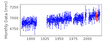
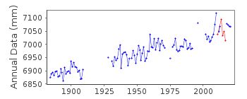
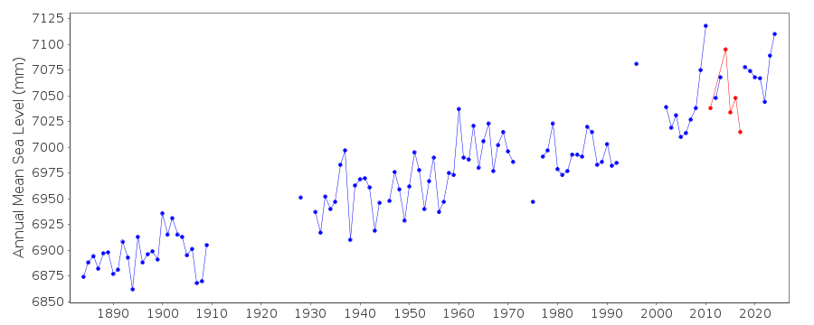
Before 1978 values based on readings of high and low watersDocumentation - date unknown
Genova is an historic station last data 1997Documentation added 1992-08-06
Italian levels may be influenced by the Messina earthquake of 1908 - See Bottari et al., Tectonophysics 202, 269-275, 1992Documentation added 1993-03-17
The stations Porto Maurizio (250/001), Napoli Arsenale (250/041) and Napoli Mandraccio (250/051) appear to each have a datum shift around 1910. Evidence for regional coherence?Documentation added 1994-04-22
Data for 1979-88 revised April 1994Documentation added 1994-07-14
Anomalously large value for December 1989 queried with authority.Documentation added 1998-12-07
For a discussion of land movements in the area of the Gulf of Naples, see the paper by G.Berrino in Tectonophysics,294,323-332,1998.Documentation added 1999-04-28
1989 revised, 28th April 1999Documentation added 2000-01-25
Genova 250/011 RLR(1963) is 10.2m below BMDocumentation added 2016-01-22
A value of MTL-MSL=-2 mm has been applied to the RLR data for the period 1884-1977. The values were derived using the GESLA2 (high-frequency tide gauge) dataset using harmonic constituents.Documentation added 2022-11-22
Data between 2014-2017 are not included in the RLR dataset as they are interpolated from a nearby radar stationDocumentation added 2023-01-20
After the supplier provided further information, data for 2011-06, 2014-03 to 2017-08 and 2017-10 have been granted RLR status but the data points have been flagged. The supplier has explained that during these periods, gaps in data from the float gauge have been filled in using data from a nearby radar sensor. These gaps are typically between 12 and 24 hours long. There are small differences between the two sensors, typically a few millimetres, but rarely above a centimetre. For each period filled, the 24 hours before and after the gap have been used to calculate an adjustment to apply to the data.Data Authority
Istituto Idrografico della MarinaPasso Osservatorio 4
16134 Genova

![]()
![]()
![]()
