Data
- Obtaining
- Supplying
- High-Frequency
- Bottom Pressure Records
- Other Long Records
- GLOSS/ODINAFRICA Calibration Data
Donate
Donate to PSMSL
Data Notes
- Individual Station Data and Plot Notes
- Referencing the Data Set
- PSMSL Help File
- 2010 Changes to the PSMSL Data Files
Extracted from Database
08 Dec 2025
Station Information
| Station ID: | 574 |
| Latitude: | -32.55 |
| Longitude: | 137.783333 |
| Coastline code: | 680 |
| Station code: | 401 |
| Country: | AUSTRALIA |
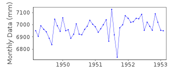
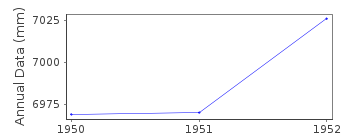
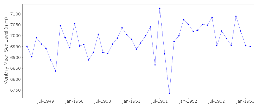
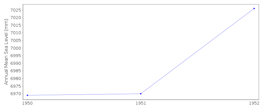
| Time span of RLR data: | 1949 – 1953 |
| RLR completeness (%): | 80 |
| Time span of metric data: | 1949 – 1983 |
| Metric completeness (%): | 18 |
| Date of last update: | 11 Mar 1987 |
| Green Arrow: | Current Station |
| Yellow Marker: | Neighbouring RLR Station |
| Red Marker: | Neighbouring Metric Station |
Please note: In many cases, the station position in our database is accurate to only one minute. Thus, the tide gauge may not appear to be on the coast.
Tide Gauge Data
Station Documentation
Link to RLR information.Documentation added 1991-06-11
Port Augusta 680/401 RLR(1952) is 11.0m below BM Valve ChamberDocumentation added 1995-05-02
Station density along some sections of the Australian coast has meant that station codes 601 onwards have been re-ordered compared to those in earlier versions of the PSMSL data set.Data for 1949-1953 was supplied by the Department of Marine and Harbours, Adelaide
Documentation added 2012-09-24
This is an historic station. Data span 1949-1953.Data Authority
National Tidal CentreBureau of Meteorology
PO Box 421
Kent Town 5071
South Australia
Documentation added 2010-08-12
Formerly known as the National Tidal Facility

![]()
![]()
![]()
