Data
- Obtaining
- Supplying
- High-Frequency
- Bottom Pressure Records
- Other Long Records
- GLOSS/ODINAFRICA Calibration Data
Donate
Donate to PSMSL
Data Notes
- Individual Station Data and Plot Notes
- Referencing the Data Set
- PSMSL Help File
- 2010 Changes to the PSMSL Data Files
Extracted from Database
11 Mar 2024
Station Information
| Station ID: | 572 |
| Latitude: | 10.4 |
| Longitude: | -75.55 |
| GLOSS ID: | 207 |
| Coastline code: | 902 |
| Station code: | 21 |
| Country: | COLOMBIA |
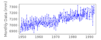
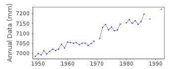
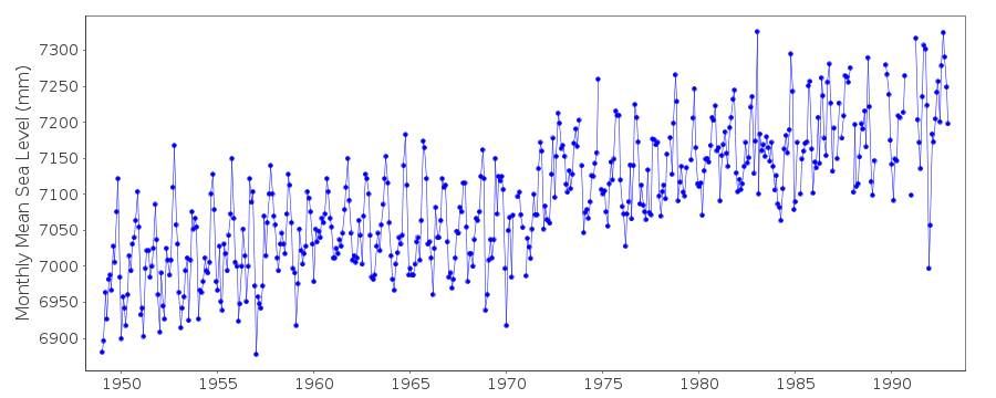
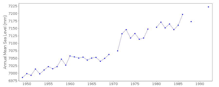
| Time span of RLR data: | 1949 – 1992 |
| RLR completeness (%): | 95 |
| Time span of metric data: | 1949 – 1993 |
| Metric completeness (%): | 94 |
| Date of last update: | 20 Apr 1994 |
| Green Arrow: | Current Station |
| Yellow Marker: | Neighbouring RLR Station |
| Red Marker: | Neighbouring Metric Station |
Please note: In many cases, the station position in our database is accurate to only one minute. Thus, the tide gauge may not appear to be on the coast.
Tide Gauge Data
Additional Data Sources (guide to additional data sources)
Nearby GNSS Stations from SONEL: CARTNearby Real Time Stations from VLIZ: cart
Research Quality Data from UHSLC station 265: hourly and daily
Station Documentation
Link to RLR information.Documentation - date unknown
Prior to 1970 data supplied by N.O.A.A.Data prior to 1985 received from the Geographical Institute Colombia
Documentation added 1991-06-11
Cartagena 902/021 RLR(1964) is 9.1m below BM4Documentation added 1992-02-12
Gauge affected by siltationDocumentation added 1994-04-20
From January 1993 gauge at CIOH building1991-92 data from Stevens gauge, 1993 (Feb-July) data from digital gauge
Data Authority
I.D.E.A.M.Carrera 5a, No.15-80 Piso 18
Aa 18633 Santafe de Bogota Dc

![]()
![]()
![]()
