Data
- Obtaining
- Supplying
- High-Frequency
- Bottom Pressure Records
- Other Long Records
- GLOSS/ODINAFRICA Calibration Data
Donate
Donate to PSMSL
Data Notes
- Individual Station Data and Plot Notes
- Referencing the Data Set
- PSMSL Help File
- 2010 Changes to the PSMSL Data Files
Extracted from Database
20 Jul 2026
Station Information
| Station ID: | 546 |
| Latitude: | 44.016667 |
| Longitude: | 145.866667 |
| GLOSS ID: | 90 |
| Coastline code: | 630 |
| Station code: | 1 |
| Country: | RUSSIAN FEDERATION |
| Time span of data: | 1948 – 1994 |
| Completeness (%): | 95 |
| Date of last update: | 25 Jan 1996 |
| Green Arrow: | Current Station |
| Yellow Marker: | Neighbouring RLR Station |
| Red Marker: | Neighbouring Metric Station |
Please note: In many cases, the station position in our database is accurate to only one minute. Thus, the tide gauge may not appear to be on the coast.
Tide Gauge Data
Station Documentation
Link to RLR information.Documentation added 1991-06-11
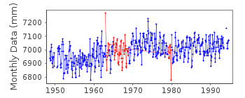
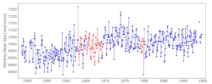
Yuzhno Kurilsk 630/001 RLR(1964) is 51.1m below BMDocumentation added 1993-07-29
Anomalously large value January 1963 and low value November 1979 - correct as received from authority.Documentation added 1995-08-29
A destructive earthquake and tsunami occurred in the Kuril Islands on 4 October 1994 - see Earth System Monitor, 5(4), June 1995.Documentation added 1996-02-28
No data for 1995 - gauge malfunctionDocumentation added 1998-04-06
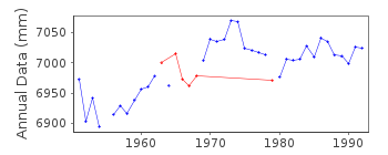
NB the station codes for this country/area do not follow the coast sequentially use data 1965 - 68 (incl.) cautiously, unsure of datum stabilityDocumentation added 1999-08-19
No data after 1994 because the gauge was damagedDocumentation added 2002-05-21
Yuzho-Kurilsk confirmed as malfunctioned, probably in 1994.Documentation added 2003-05-29
No data in 2002 due to malfunctioning gauge.Data Authority
World Data CenterRussian Federal Service for Hydrometeorology
and Environmental Monitoring
6 Korolev Street, 249035 Obninsk
Kaluga Region

![]()
![]()
![]()
