Data
- Obtaining
- Supplying
- High-Frequency
- Bottom Pressure Records
- Other Long Records
- GLOSS/ODINAFRICA Calibration Data
Donate
Donate to PSMSL
Data Notes
- Individual Station Data and Plot Notes
- Referencing the Data Set
- PSMSL Help File
- 2010 Changes to the PSMSL Data Files
Extracted from Database
11 Mar 2024
Station Information
| Station ID: | 539 |
| Latitude: | -14.28 |
| Longitude: | -170.69 |
| GLOSS ID: | 144 |
| Coastline code: | 745 |
| Station code: | 1 |
| Country: | AMERICAN SAMOA |
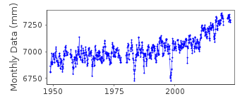
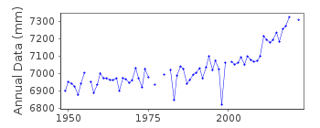
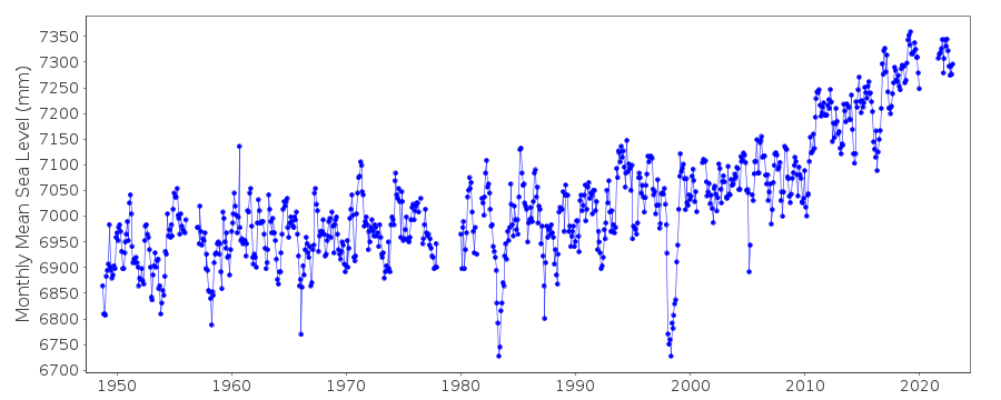
| Time span of data: | 1948 – 2022 |
| Completeness (%): | 91 |
| Date of last update: | 26 Jan 2024 |
| Green Arrow: | Current Station |
| Yellow Marker: | Neighbouring RLR Station |
| Red Marker: | Neighbouring Metric Station |
Please note: In many cases, the station position in our database is accurate to only one minute. Thus, the tide gauge may not appear to be on the coast.
Tide Gauge Data
Additional Data Sources (guide to additional data sources)
Nearby GNSS Stations from SONEL: ASPANearby Real Time Stations from VLIZ: pagx, pago
Fast Delivery Data from UHSLC station 56: hourly and daily
Research Quality Data from UHSLC station 56: hourly and daily
Station Documentation
Link to RLR information.Documentation added 1991-06-11
Pago Pago 745/001 RLR(1974) is 9.8m below BM1Documentation added 2011-03-15
Although not obvious from the data there was a tsunami in the area 29-30 September 2009.Documentation added 2011-11-23
Using information from the NOAA website the RLR diagram has been revised. Previous Primary benchmark NO 1 1948 no longer appears in the NOAA reports. Primary benchmark is now 0000 S 1993 AS 29 ASPA 2002 2.557m above gauge datum.Documentation added 2013-02-28
Data for 2011 and 2012 almost look like a datum change but the profile must be real as that is how it appears on the NOAA website. It also buddy checks well with Apia B id. 1840Data Authority
N.O.A.A. / N.O.S.N/oes33, Ssmc4, Room 6531
1305 East-West Highway
Silver Spring,
MD 20910

![]()
![]()
![]()
