Data
- Obtaining
- Supplying
- High-Frequency
- Bottom Pressure Records
- Other Long Records
- GLOSS/ODINAFRICA Calibration Data
Donate
Donate to PSMSL
Data Notes
- Individual Station Data and Plot Notes
- Referencing the Data Set
- PSMSL Help File
- 2010 Changes to the PSMSL Data Files
Extracted from Database
11 Mar 2024
Station Information
| Station ID: | 537 |
| Latitude: | 7.083333 |
| Longitude: | 125.633333 |
| GLOSS ID: | 71 |
| Coastline code: | 660 |
| Station code: | 121 |
| Country: | PHILIPPINES |
| Time span of data: | 1948 – 2022 |
| Completeness (%): | 81 |
| Date of last update: | 13 Jun 2023 |
| Green Arrow: | Current Station |
| Yellow Marker: | Neighbouring RLR Station |
| Red Marker: | Neighbouring Metric Station |
Please note: In many cases, the station position in our database is accurate to only one minute. Thus, the tide gauge may not appear to be on the coast.
Tide Gauge Data
Additional Data Sources (guide to additional data sources)
Nearby Real Time Stations from VLIZ: davoFast Delivery Data from UHSLC station 372: hourly and daily
Research Quality Data from UHSLC station 372: hourly and daily
Station Documentation
Link to RLR information.Documentation added 1991-06-11
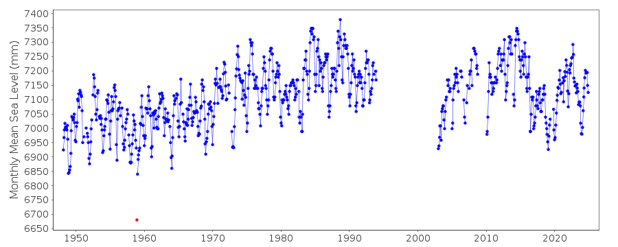
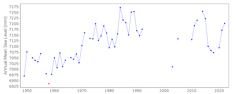
Davao 660/121 RLR(1969) is 9.0m below BM11Documentation added 1993-06-17
December 1958 for Davao is anomalously low.Documentation added 2010-10-14
The first mention of datum for Davao is in a letter dated 16.03.1959 where the datum is said to be 13.01ft relative to BM 4. A letter dated 17.12.1987 gives a datum of BM 11 3.861 relative to datum TSO 1947. Throughout the names BM 1 and BM 11 seem to be inter-changeable.Data for 1988-1992 BM 1/11 3.852m above TSO 1947. In 1993 there is a reference to BM 8 3.446m relative to TSO 1947.There is no data for Davao 1994-2002 as the data is either very poor quality or missing.From 2003 data onwards benchmark is BM 18 4.849m above TSO 1947. Occasionallythis is rounded to 4.85m.Davao was made RLR in 2010 Gauge type is SUTRON
Documentation added 2012-02-27
The data from the gauges re-instatement is possibly suspect. However, the remoteness of the Philippine stations makes it difficult to confirm this.The relationship between BM 18 and TSO 1947 is now given as 5.746mDocumentation added 2018-02-07
following a query revised values for November and December 2016 have been supplied.Data Authority
National Mapping and Resource Information AuthorityHydrography Department
421 Barraca St,
San Nicolas 1010
Manila

![]()
![]()
![]()
