Data
- Obtaining
- Supplying
- High-Frequency
- Bottom Pressure Records
- Other Long Records
- GLOSS/ODINAFRICA Calibration Data
Donate
Donate to PSMSL
Data Notes
- Individual Station Data and Plot Notes
- Referencing the Data Set
- PSMSL Help File
- 2010 Changes to the PSMSL Data Files
Extracted from Database
09 Feb 2026
Station Information
| Station ID: | 495 |
| Latitude: | 59.45 |
| Longitude: | -135.326667 |
| Coastline code: | 821 |
| Station code: | 41 |
| Country: | UNITED STATES |
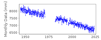
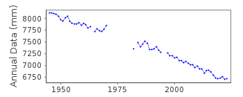
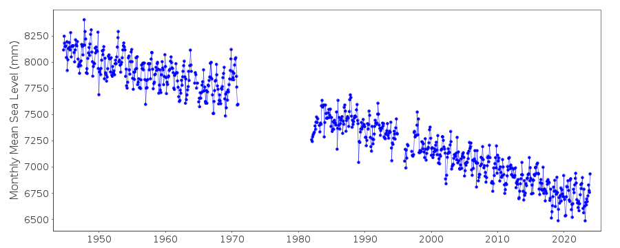
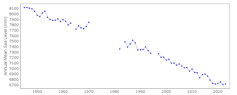
| Time span of data: | 1944 – 2025 |
| Completeness (%): | 83 |
| Date of last update: | 28 Jan 2026 |
| Green Arrow: | Current Station |
| Yellow Marker: | Neighbouring RLR Station |
| Red Marker: | Neighbouring Metric Station |
Please note: In many cases, the station position in our database is accurate to only one minute. Thus, the tide gauge may not appear to be on the coast.
Tide Gauge Data
Station Documentation
Link to RLR information.Documentation added 1991-06-11
Skagway, Alaska 821/041 RLR(1974) is 14.0m below BM1Documentation added 1992-04-02
SOUTH ALASKAN COASTLINE EARTHQUAKE PRONE - E.G. MAGNITUDE 9.2 EARTHQUAKE OF 28 MARCH 1964 - SEE SAVAGE AND PLAFKER, JGR,96(B3), 4325-4335, 1991 1944 - 1970 VALUES BASED ON 24 READINGS PER DAYDocumentation added 1995-08-29
A tsunami triggered by a landslide and not an earthquake occurred on 1 November 1994 in Skagway Harbor - see Earth System Monitor,5(4), June 1995.Documentation added 2011-11-23
Using Information from the NOAA website the RLR diagram has been revised. Previous Primary benchmark BM 1 11.015m above TGZ does not now appear in the NOAA report. Current Primary benchmark NO 11 1969 11.646m above TGZ appeared on the original RLR diagram. The original RLR year was 1974 data 1971-1974 was deleted to correspond with the publication 'Sea Level Variations in U.S. 1855-1986'. RLR was re-defined using RLR year 2009. New RLR factor is 3.585m.Data Authority
N.O.A.A. / N.O.S.N/oes33, Ssmc4, Room 6531
1305 East-West Highway
Silver Spring,
MD 20910

![]()
![]()
![]()
