Data
- Obtaining
- Supplying
- High-Frequency
- Bottom Pressure Records
- Other Long Records
- GLOSS/ODINAFRICA Calibration Data
Donate
Donate to PSMSL
Data Notes
- Individual Station Data and Plot Notes
- Referencing the Data Set
- PSMSL Help File
- 2010 Changes to the PSMSL Data Files
Extracted from Database
26 Jan 2026
Station Information
| Station ID: | 490 |
| Latitude: | 36.12077 |
| Longitude: | -5.434973 |
| Coastline code: | 220 |
| Station code: | 11 |
| Country: | SPAIN |
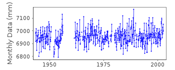
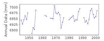
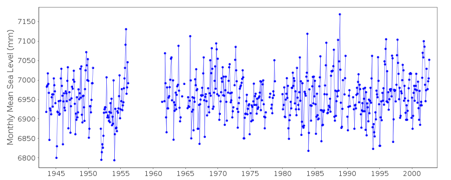
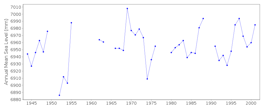
| Time span of data: | 1943 – 2002 |
| Completeness (%): | 81 |
| Date of last update: | 20 Nov 2006 |
| Green Arrow: | Current Station |
| Yellow Marker: | Neighbouring RLR Station |
| Red Marker: | Neighbouring Metric Station |
Please note: In many cases, the station position in our database is accurate to only one minute. Thus, the tide gauge may not appear to be on the coast.
Tide Gauge Data
Additional Data Sources (guide to additional data sources)
Nearby Real Time Stations from VLIZ: alge, gibr3Fast Delivery Data from UHSLC station 289: hourly and daily
Research Quality Data from UHSLC station 289: hourly and daily
Station Documentation
Link to RLR information.Documentation added 1999-03-22
Data for 1992-96 revisedDocumentation added 2000-04-25
Algeciras 220/011 RLR(1996) is 8.5m below BM NGR 15Documentation added 2006-12-06
Full dataset 1943-2002 updated after receiving revised values fromDocumentation added 2006-12-06
the IEO. Copies of previous values kept.Datum of the data confirmed to be 2.30m below benchmark NGR15.
No further data will be available from this exact site as
harbour is being modified.
New tide gauge to be installed.
Documentation added 2012-01-19
New gauge for Algeciras is Algeciras B Lat 36 7.17N Long 5 26.13W. Datacommences November 2006 database id.2117
Data Authority
Instituto Español de OceanografíaCorazón de María, 8
28002, Madrid

![]()
![]()
![]()
