Data
- Obtaining
- Supplying
- High-Frequency
- Bottom Pressure Records
- Other Long Records
- GLOSS/ODINAFRICA Calibration Data
Donate
Donate to PSMSL
Data Notes
- Individual Station Data and Plot Notes
- Referencing the Data Set
- PSMSL Help File
- 2010 Changes to the PSMSL Data Files
Extracted from Database
09 Feb 2026
Station Information
| Station ID: | 449 |
| Latitude: | 13.15 |
| Longitude: | 100.816667 |
| Coastline code: | 600 |
| Station code: | 51 |
| Country: | THAILAND |
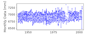
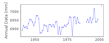
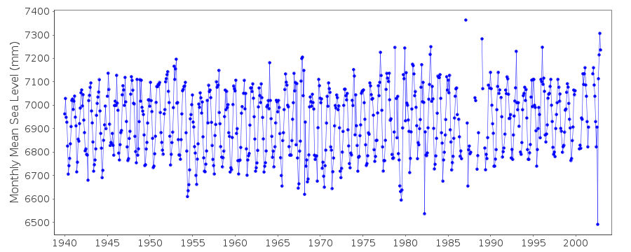
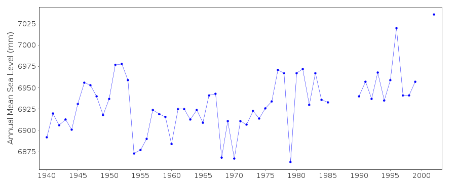
| Time span of data: | 1940 – 2002 |
| Completeness (%): | 95 |
| Date of last update: | 28 May 2003 |
| Green Arrow: | Current Station |
| Yellow Marker: | Neighbouring RLR Station |
| Red Marker: | Neighbouring Metric Station |
Please note: In many cases, the station position in our database is accurate to only one minute. Thus, the tide gauge may not appear to be on the coast.
Tide Gauge Data
Station Documentation
Link to RLR information.Documentation added 1991-06-11
Ko Sichang 600/051 RLR(1981) is 9.1m below BM PSCIDocumentation added 1993-07-12
Ko Sichang 600/051 RLR(1981) is 9.1m below BM PSCIDocumentation added 2003-05-28
Reported monthly mean sea level for August 2002 is suspiciously low.Ko Sichang is an historic station last data 2002
Data Authority
Oceanographic DivisionHydrographic Department
Royal Thai Navy
222 Rimtang-Rodfai-kao Road
Bangna, Bangkok 10260

![]()
![]()
![]()
