Data
- Obtaining
- Supplying
- High-Frequency
- Bottom Pressure Records
- Other Long Records
- GLOSS/ODINAFRICA Calibration Data
Donate
Donate to PSMSL
Data Notes
- Individual Station Data and Plot Notes
- Referencing the Data Set
- PSMSL Help File
- 2010 Changes to the PSMSL Data Files
Extracted from Database
22 Jun 2026
Station Information
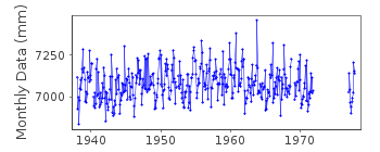
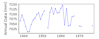
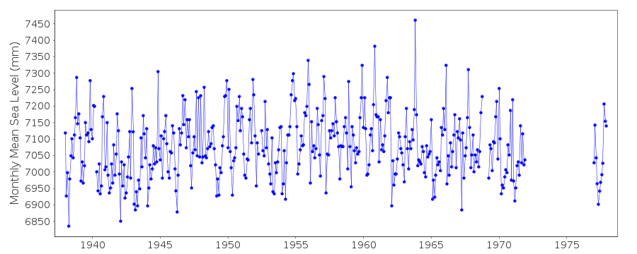
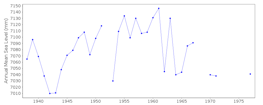
| Station ID: | 435 |
| Latitude: | 54.15 |
| Longitude: | -4.466667 |
| Coastline code: | 170 |
| Station code: | 231 |
| Country: | ISLE OF MAN |
| Time span of data: | 1938 – 1977 |
| Completeness (%): | 86 |
| Date of last update: | 07 Apr 1992 |
| Green Arrow: | Current Station |
| Yellow Marker: | Neighbouring RLR Station |
| Red Marker: | Neighbouring Metric Station |
Please note: In many cases, the station position in our database is accurate to only one minute. Thus, the tide gauge may not appear to be on the coast.
Tide Gauge Data
Station Documentation
Link to RLR information.Documentation added 1991-06-11
Douglas 170/231 RLR(1964) is 13.3m below TGBMDocumentation added 1993-07-12
Douglas 170/231 RLR(1964) is 13.3m below TGBMDocumentation added 1994-09-21
November 1936 - March 1969 Evershed & Vignoles gaugeApril 1969 onwards Munro gauge
Data reduced by IOM Harbour Board
Documentation added 2001-01-02
Recent work on vertical land movements in the UK can be found fromthe University of Nottingham web site:
http://ukcogr.iessg.nottingham.ac.uk/~eosi/
Data Authority
Isle of Man Harbour BoardEngineers Office
Douglas
Isle of Man

![]()
![]()
![]()
