Data
- Obtaining
- Supplying
- High-Frequency
- Bottom Pressure Records
- Other Long Records
- GLOSS/ODINAFRICA Calibration Data
Donate
Donate to PSMSL
Data Notes
- Individual Station Data and Plot Notes
- Referencing the Data Set
- PSMSL Help File
- 2010 Changes to the PSMSL Data Files
Extracted from Database
08 Dec 2025
Station Information
| Station ID: | 431 |
| Latitude: | -34.9 |
| Longitude: | -56.25 |
| GLOSS ID: | 300 |
| Coastline code: | 870 |
| Station code: | 11 |
| Country: | URUGUAY |
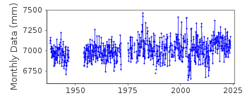
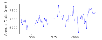
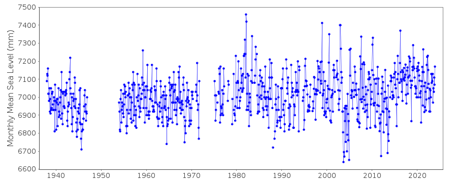
| Time span of data: | 1938 – 2024 |
| Completeness (%): | 82 |
| Date of last update: | 09 May 2025 |
| Green Arrow: | Current Station |
| Yellow Marker: | Neighbouring RLR Station |
| Red Marker: | Neighbouring Metric Station |
Please note: In many cases, the station position in our database is accurate to only one minute. Thus, the tide gauge may not appear to be on the coast.
Tide Gauge Data
Additional Data Sources (guide to additional data sources)
Nearby GNSS Stations from SONEL: MTV1, MTV2, UYMOStation Documentation
Link to RLR information.Documentation added 1991-11-20
BEFORE 1975 GAUGE AT MUELLE WASHINGTON, 34 55 S 56 13 W 1975-1983 GAUGE AT MUELLE MATARAS, 34 53 S 56 11 WDocumentation added 1993-07-12
Montevideo 870/011 RLR(1962) is 29.9m below BM Repere del CabildoDocumentation added 1994-07-14
Record will be affected by the confluence of the Parana and Uruguay Rivers.Documentation added 2009-05-21
Data for 1995-2008 received from SOHMA. 1995 data had been revised. Full dataset entered plot 2003/4 seems low.Data Authority
SOHMA (Oceanographic, Hydrography andMeteorology Service of the Uruguayan Navy)
Capurro 980
MONTEVIDEO

![]()
![]()
![]()
