Data
- Obtaining
- Supplying
- High-Frequency
- Bottom Pressure Records
- Other Long Records
- GLOSS/ODINAFRICA Calibration Data
Donate
Donate to PSMSL
Data Notes
- Individual Station Data and Plot Notes
- Referencing the Data Set
- PSMSL Help File
- 2010 Changes to the PSMSL Data Files
Extracted from Database
09 Feb 2026
Station Information
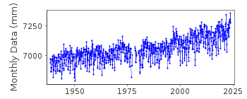
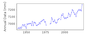
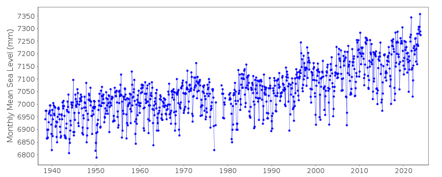
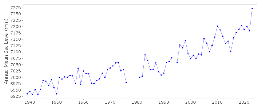
| Station ID: | 429 |
| Latitude: | 41.36 |
| Longitude: | -72.09 |
| Coastline code: | 960 |
| Station code: | 151 |
| Country: | UNITED STATES |
| Time span of data: | 1938 – 2025 |
| Completeness (%): | 96 |
| Date of last update: | 28 Jan 2026 |
| Green Arrow: | Current Station |
| Yellow Marker: | Neighbouring RLR Station |
| Red Marker: | Neighbouring Metric Station |
Please note: In many cases, the station position in our database is accurate to only one minute. Thus, the tide gauge may not appear to be on the coast.
Tide Gauge Data
Additional Data Sources (guide to additional data sources)
Nearby GNSS Stations from SONEL: CTGRResearch Quality Data from UHSLC station 744: hourly and daily
Station Documentation
Link to RLR information.Documentation added 1991-06-11
New London 960/151 RLR(1964) is 9.7m below BM13Documentation added 2011-08-17
Using NOAA data the RLR diagram has been re-drawn. Primary benchmark is now 1490 B 1998 5.032m above gauge datum. Benchmark 15 1947 4.88m relative to gauge datum is listed as the second benchmark. Benchmark 13 1938 from the original RLR diagram does not appear in the Epoch 1983-2001 but does appear in the superseded Epoch 1960-1978 with the same value of 4.176m above gauge datum.Data Authority
N.O.A.A. / N.O.S.N/oes33, Ssmc4, Room 6531
1305 East-West Highway
Silver Spring,
MD 20910

![]()
![]()
![]()
