Data
- Obtaining
- Supplying
- High-Frequency
- Bottom Pressure Records
- Other Long Records
- GLOSS/ODINAFRICA Calibration Data
Donate
Donate to PSMSL
Data Notes
- Individual Station Data and Plot Notes
- Referencing the Data Set
- PSMSL Help File
- 2010 Changes to the PSMSL Data Files
Extracted from Database
11 Mar 2024
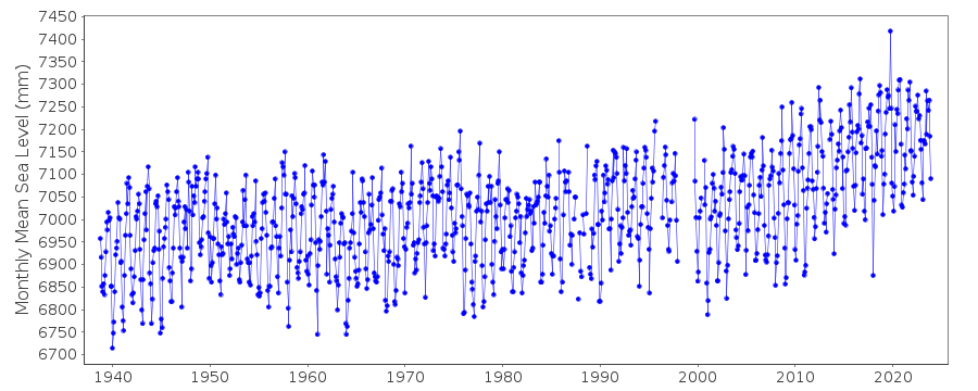
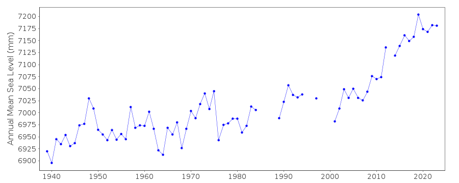
Station Information
| Station ID: | 428 |
| Latitude: | 29.135 |
| Longitude: | -83.031667 |
| Coastline code: | 940 |
| Station code: | 52 |
| Country: | UNITED STATES |
| Time span of data: | 1938 – 2023 |
| Completeness (%): | 95 |
| Date of last update: | 10 Jan 2024 |
| Green Arrow: | Current Station |
| Yellow Marker: | Neighbouring RLR Station |
| Red Marker: | Neighbouring Metric Station |
Please note: In many cases, the station position in our database is accurate to only one minute. Thus, the tide gauge may not appear to be on the coast.
Tide Gauge Data
Station Documentation
Link to RLR information.Documentation added 1991-06-11
Cedar Keys II 940/052 RLR(1974) is 8.9m below BM11Documentation added 1993-07-29
Many stations on the Gulf coast have large values for September 1961.Documentation added 2011-07-27
Data is downloaded directly from the NOAA website. Datum information also downloaded NOAA Primary Benchmark is BM 8 2.347m above the datum.Data Authority
N.O.A.A. / N.O.S.N/oes33, Ssmc4, Room 6531
1305 East-West Highway
Silver Spring,
MD 20910

![]()
![]()
![]()
