Data
- Obtaining
- Supplying
- High-Frequency
- Bottom Pressure Records
- Other Long Records
- GLOSS/ODINAFRICA Calibration Data
Donate
Donate to PSMSL
Data Notes
- Individual Station Data and Plot Notes
- Referencing the Data Set
- PSMSL Help File
- 2010 Changes to the PSMSL Data Files
Extracted from Database
08 Dec 2025
Station Information
| Station ID: | 421 |
| Latitude: | 20.133333 |
| Longitude: | 92.9 |
| GLOSS ID: | 37 |
| Coastline code: | 530 |
| Station code: | 1 |
| Country: | MYANMAR |
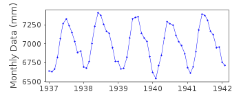
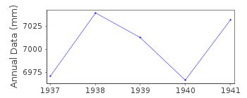
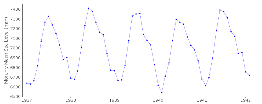
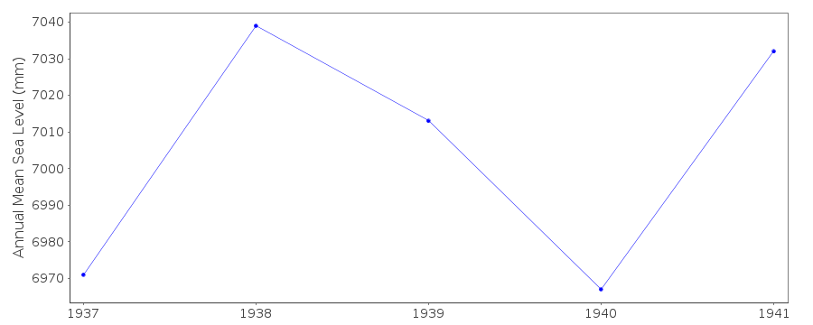
| Time span of data: | 1937 – 1942 |
| Completeness (%): | 86 |
| Date of last update: | 01 Jan 1980 |
| Green Arrow: | Current Station |
| Yellow Marker: | Neighbouring RLR Station |
| Red Marker: | Neighbouring Metric Station |
Please note: In many cases, the station position in our database is accurate to only one minute. Thus, the tide gauge may not appear to be on the coast.
Tide Gauge Data
Additional Data Sources (guide to additional data sources)
Fast Delivery Data from UHSLC station 907: hourly and dailyResearch Quality Data from UHSLC station 907: hourly and daily
Station Documentation
Link to RLR information.Documentation added 1991-06-11
Akyab 530/001 RLR(1941) is 10.6m below BM 19Documentation added 1993-07-12
Akyab 530/001 RLR(1941) is 10.6m below BM 19Documentation added 2012-08-08
It has been confirmed that the monthly means for Akyab were based on high andlow
waters.
Akyab is an historic station and has been swithched as 'inactive'.
Data Authority
Survey of IndiaGeodetic and Research Branch
17 E.C. Road
Dehra Dun
PIN 248 001

![]()
![]()
![]()
