Data
- Obtaining
- Supplying
- High-Frequency
- Bottom Pressure Records
- Other Long Records
- GLOSS/ODINAFRICA Calibration Data
Donate
Donate to PSMSL
Data Notes
- Individual Station Data and Plot Notes
- Referencing the Data Set
- PSMSL Help File
- 2010 Changes to the PSMSL Data Files
Extracted from Database
11 Mar 2024
WARNING: QCFLAG EXISTS. PLEASE READ THE DOCUMENTATION.
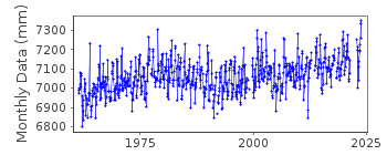
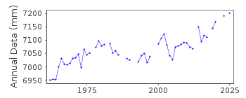
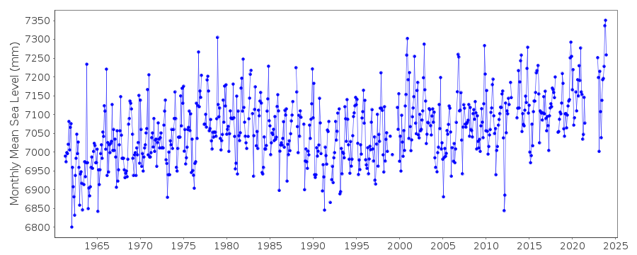
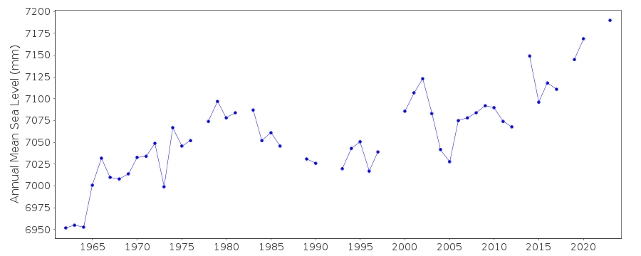
Station Information
| Station ID: | 350 |
| Latitude: | 50.80225 |
| Longitude: | -1.11125 |
| Coastline code: | 170 |
| Station code: | 131 |
| Country: | UNITED KINGDOM |
| Time span of RLR data: | 1961 – 2023 |
| RLR completeness (%): | 92 |
| Time span of metric data: | 1930 – 2023 |
| Metric completeness (%): | 63 |
| Link to ellipsoid: | Available |
| Date of last update: | 02 Feb 2024 |
| Green Arrow: | Current Station |
| Yellow Marker: | Neighbouring RLR Station |
| Red Marker: | Neighbouring Metric Station |
Please note: In many cases, the station position in our database is accurate to only one minute. Thus, the tide gauge may not appear to be on the coast.
Tide Gauge Data
Additional Data Sources (guide to additional data sources)
Nearby GNSS Stations from SONEL: PMTGNearby Real Time Stations from VLIZ: ptmt
Station Documentation
Link to RLR information.Documentation added 1991-06-11
Portsmouth 170/131 RLR(1971) is 10.2m below BM SU6270 0053Documentation added 1992-05-05
Prior to 1991 data were received from UK Hydrographic OfficeDocumentation added 1994-07-21
Gauge details prior to 1960 are unclear. In 1960 a Lea stilling well gauge was installed, replaced in January 1991 by an "A Class" bubbler system.Documentation added 1994-10-27
A letter to the Dock and Harbour Authority, No.61, page 385, 1981 by Webber and Walden castes doubts on the stability of the datum at Portsmouth during the 1960s and 1970s.Documentation added 1997-07-16
Revised BM information for 1980-96Documentation added 2001-01-02
Recent work on vertical land movements in the UK can be found from the University of Nottingham web site:http://ukcogr.iessg.nottingham.ac.uk/~eosi/Documentation added 2012-05-24
Following re-leveling the Grid Reference for the Primary banchmark has changed from SU 6270 0053 to SU 6269 0053.Documentation added 2014-07-04
There were no MSL's calculated for Portsmouth before August 2013 this was due to the fact that the primary channel, channel 2 was recording a constant -1.124m because of a leak on thesystem.
Documentation added 2015-05-18
TGI were at site 16.01.14 to carry out general maintenance and change the compressor.Data Authority
Horizon HouseDeanery Road
BS1 5AH
Bristol

![]()
![]()
![]()
