Data
- Obtaining
- Supplying
- High-Frequency
- Bottom Pressure Records
- Other Long Records
- GLOSS/ODINAFRICA Calibration Data
Donate
Donate to PSMSL
Data Notes
- Individual Station Data and Plot Notes
- Referencing the Data Set
- PSMSL Help File
- 2010 Changes to the PSMSL Data Files
Extracted from Database
11 Mar 2024
Station Information
| Station ID: | 288 |
| Latitude: | 43.08 |
| Longitude: | -70.741667 |
| Coastline code: | 960 |
| Station code: | 177 |
| Country: | UNITED STATES |
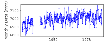
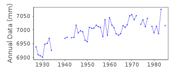
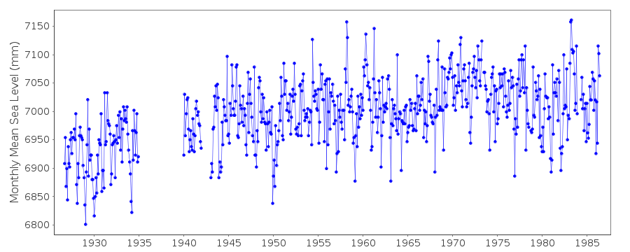
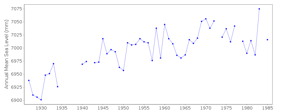
| Time span of data: | 1926 – 1986 |
| Completeness (%): | 87 |
| Date of last update: | 26 Oct 1990 |
| Green Arrow: | Current Station |
| Yellow Marker: | Neighbouring RLR Station |
| Red Marker: | Neighbouring Metric Station |
Please note: In many cases, the station position in our database is accurate to only one minute. Thus, the tide gauge may not appear to be on the coast.
Tide Gauge Data
Additional Data Sources (guide to additional data sources)
Nearby GNSS Stations from SONEL: POR2, POR4Station Documentation
Link to RLR information.Documentation - date unknown
1926-68 DATA FROM PORTSMOUTH (NAVY YARD) SITE1969-1972 DATA FROM SEAVEY IS, BACK CHANNEL SITE
1973 TO DATE DATA FROM SEAVEY IS,BERTH 2 SITE
Documentation added 1991-06-11
Seavey Island 960/177 RLR(1972) is 12.9m below BM12Documentation added 1993-07-12
Seavey Island 960/177 RLR(1972) is 12.9m below BM12Documentation added 2012-02-15
Seavey Island is now an Historic station. Last data received was that for 1986.Information from the NOAA website confirms Primary benchmark to be NO 21 1975
$.59m above TGZ. Benchmark 12 from the original RLR diagram no longer features
on the NOAA website.
Data Authority
N.O.A.A. / N.O.S.N/oes33, Ssmc4, Room 6531
1305 East-West Highway
Silver Spring,
MD 20910

![]()
![]()
![]()
