Data
- Obtaining
- Supplying
- High-Frequency
- Bottom Pressure Records
- Other Long Records
- GLOSS/ODINAFRICA Calibration Data
Donate
Donate to PSMSL
Data Notes
- Individual Station Data and Plot Notes
- Referencing the Data Set
- PSMSL Help File
- 2010 Changes to the PSMSL Data Files
Extracted from Database
06 Apr 2026
Station Information
| Station ID: | 2356 |
| Latitude: | -18.1325 |
| Longitude: | 178.4275 |
| GLOSS ID: | 122 |
| Coastline code: | 742 |
| Station code: | 14 |
| Country: | FIJI |
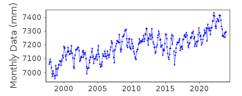
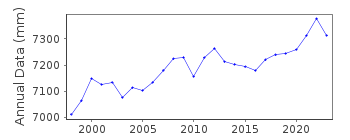
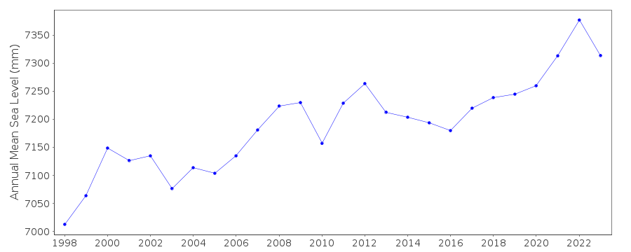
| Time span of data: | 1997 – 2025 |
| Completeness (%): | 94 |
| Date of last update: | 20 Mar 2025 |
| Green Arrow: | Current Station |
| Yellow Marker: | Neighbouring RLR Station |
| Red Marker: | Neighbouring Metric Station |
Please note: In many cases, the station position in our database is accurate to only one minute. Thus, the tide gauge may not appear to be on the coast.
Tide Gauge Data
Additional Data Sources (guide to additional data sources)
Nearby GNSS Stations from SONEL: SUVA, USP1Nearby Real Time Stations from VLIZ: viti
Fast Delivery Data from UHSLC station 18: hourly and daily
Research Quality Data from UHSLC station 18: hourly and daily
Station Documentation
Link to RLR information.Documentation added 2019-01-29
The dataset from November 1997 has been removed from the previous UHSLC dataset. From this date the running of the station was taken over by the Australian authority the National Tidal Centre (NTC). As a consequence the station has been renamed Suva-BData Authority
National Tidal CentreBureau of Meteorology
PO Box 421
Kent Town 5071
South Australia
Documentation added 2010-08-12
Formerly known as the National Tidal Facility

![]()
![]()
![]()
