Data
- Obtaining
- Supplying
- High-Frequency
- Bottom Pressure Records
- Other Long Records
- GLOSS/ODINAFRICA Calibration Data
Donate
Donate to PSMSL
Data Notes
- Individual Station Data and Plot Notes
- Referencing the Data Set
- PSMSL Help File
- 2010 Changes to the PSMSL Data Files
Extracted from Database
13 Jul 2026
Station Information
| Station ID: | 2243 |
| Latitude: | 4.893783 |
| Longitude: | -52.190483 |
| Coastline code: | 876 |
| Station code: | 3 |
| Country: | FRENCH GUIANA |
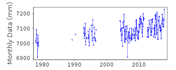
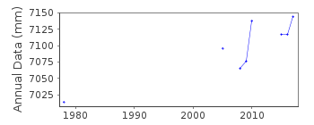
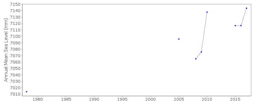
| Time span of data: | 1978 – 2018 |
| Completeness (%): | 40 |
| Date of last update: | 18 Jun 2025 |
| Green Arrow: | Current Station |
| Yellow Marker: | Neighbouring RLR Station |
| Red Marker: | Neighbouring Metric Station |
Please note: In many cases, the station position in our database is accurate to only one minute. Thus, the tide gauge may not appear to be on the coast.
Tide Gauge Data
Station Documentation
Link to RLR information.Documentation added 2016-06-21
Data for the station Ilet la Mer has only recently been added to the database. The tide gauge is on an island off French Guiana. The data comprises three separate periods January-December 1978, May 1989-October 1996 and March 2004 onwards.Documentation added 2017-04-05
There was a change in Chart Datum in November 2013 for Ilet la Mere. The new datum is 10.7cm lower than the old datum. The recently complete dataset downloaded from SONEL has been adjusted for this.Documentation added 2019-08-07
Using station information from the SHOM website the station has been made RLR. However, instead of a Benchmark name there is a description of the tide gauge. Because of this the Benchmark name has been entered on the RLR diagram TGBM.Documentation added 2025-07-16
Updated the whole dataset to ensure they include all the historical data recovered recently by SHOM and the calculated monthly and annual means match those distributed by SONEL.Data Authority
SHOM13 rue de Chatelier
29200 BREST

![]()
![]()
![]()
