Data
- Obtaining
- Supplying
- High-Frequency
- Bottom Pressure Records
- Other Long Records
- GLOSS/ODINAFRICA Calibration Data
Donate
Donate to PSMSL
Data Notes
- Individual Station Data and Plot Notes
- Referencing the Data Set
- PSMSL Help File
- 2010 Changes to the PSMSL Data Files
Extracted from Database
26 Jan 2026
Station Information
| Station ID: | 2126 |
| Latitude: | 34.408333 |
| Longitude: | -119.685 |
| Coastline code: | 823 |
| Station code: | 48 |
| Country: | UNITED STATES |
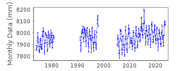
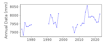
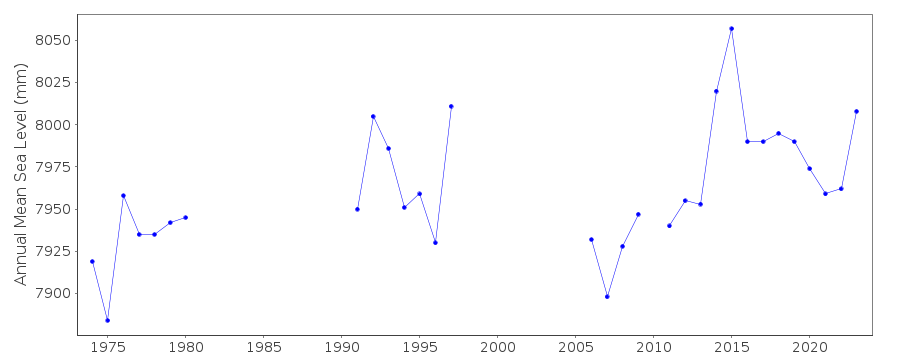
| Time span of data: | 1973 – 2024 |
| Completeness (%): | 64 |
| Date of last update: | 07 Jan 2025 |
| Green Arrow: | Current Station |
| Yellow Marker: | Neighbouring RLR Station |
| Red Marker: | Neighbouring Metric Station |
Please note: In many cases, the station position in our database is accurate to only one minute. Thus, the tide gauge may not appear to be on the coast.
Tide Gauge Data
Additional Data Sources (guide to additional data sources)
Nearby GNSS Stations from SONEL: RCA2, EOCGResearch Quality Data from UHSLC station 577: hourly and daily
Station Documentation
Link to RLR information.Documentation added 2012-01-23
Santa Barbar, California is a new station data and metadata downloaded from NOAA. Station made RLR Primary benchmark is 1340 S 2005 4.141m above TGZ. RLR factor 5.159m.Documentation added 2012-09-18
For information: Data values during the early 1980's appear to be particurlarly high. This phenomenon could be due to the El Nino Southern Oscillation (ENSO)as it is mirrored all along the Californian coast.Documentation added 2014-03-11
The datum has changed to be Mean Lower Low Water. Using the NOAA datum sheet the RLR diagram has been revised.Reference benchmark remains the same but the RLR factor has changed beacause of this.Data Authority
N.O.A.A. / N.O.S.N/oes33, Ssmc4, Room 6531
1305 East-West Highway
Silver Spring,
MD 20910

![]()
![]()
![]()
