Data
- Obtaining
- Supplying
- High-Frequency
- Bottom Pressure Records
- Other Long Records
- GLOSS/ODINAFRICA Calibration Data
Donate
Donate to PSMSL
Data Notes
- Individual Station Data and Plot Notes
- Referencing the Data Set
- PSMSL Help File
- 2010 Changes to the PSMSL Data Files
Extracted from Database
08 Dec 2025
Station Information
| Station ID: | 2118 |
| Latitude: | 17.75 |
| Longitude: | -64.705 |
| Coastline code: | 939 |
| Station code: | 15 |
| Country: | VIRGIN ISLANDS, U.S. |
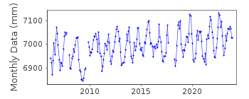
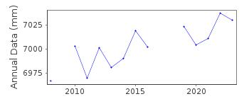
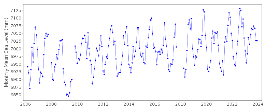
| Time span of data: | 2006 – 2024 |
| Completeness (%): | 95 |
| Date of last update: | 23 Jan 2025 |
| Green Arrow: | Current Station |
| Yellow Marker: | Neighbouring RLR Station |
| Red Marker: | Neighbouring Metric Station |
Please note: In many cases, the station position in our database is accurate to only one minute. Thus, the tide gauge may not appear to be on the coast.
Tide Gauge Data
Additional Data Sources (guide to additional data sources)
Nearby GNSS Stations from SONEL: CRO1Nearby Real Time Stations from VLIZ: lime2, stcr, lime, stcr2
Research Quality Data from UHSLC station 254: hourly and daily
Research Quality Data from UHSLC station 258: hourly and daily
Station Documentation
Link to RLR information.Documentation added 2012-01-23
Christiansted Harbour on St. Croix of the Virgin Islands is a new station downloaded from the NOAA website. Datum and benchmark details were also downloaded allowing the station to be made RLR. Primary benchmark is 1364 A 2006 10.00m above TGZ.Documentation added 2015-02-04
The RLR diagram contained an error and so has been was redrawn. However, the RLR factor applied to the data was correct, thus the RLR values have not changed.Data Authority
N.O.A.A. / N.O.S.N/oes33, Ssmc4, Room 6531
1305 East-West Highway
Silver Spring,
MD 20910

![]()
![]()
![]()
