Data
- Obtaining
- Supplying
- High-Frequency
- Bottom Pressure Records
- Other Long Records
- GLOSS/ODINAFRICA Calibration Data
Donate
Donate to PSMSL
Data Notes
- Individual Station Data and Plot Notes
- Referencing the Data Set
- PSMSL Help File
- 2010 Changes to the PSMSL Data Files
Extracted from Database
08 Dec 2025
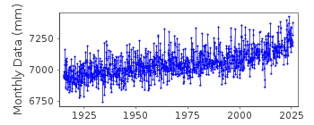
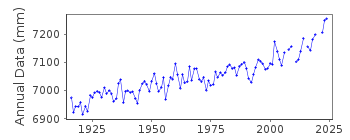
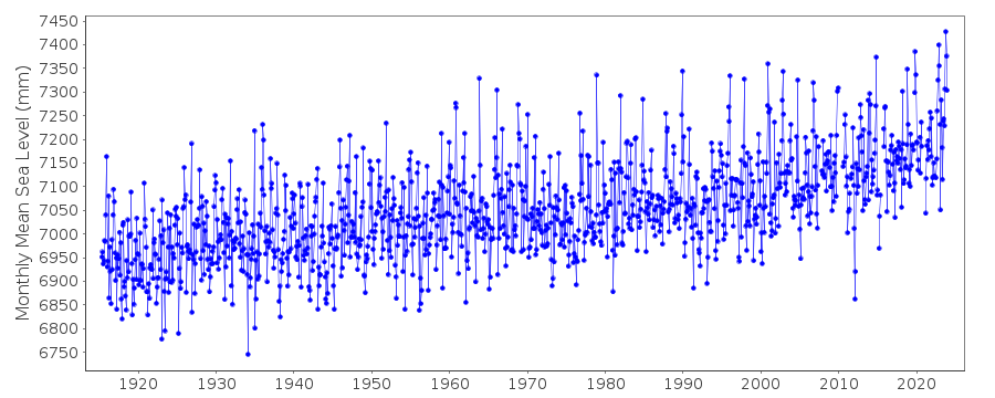
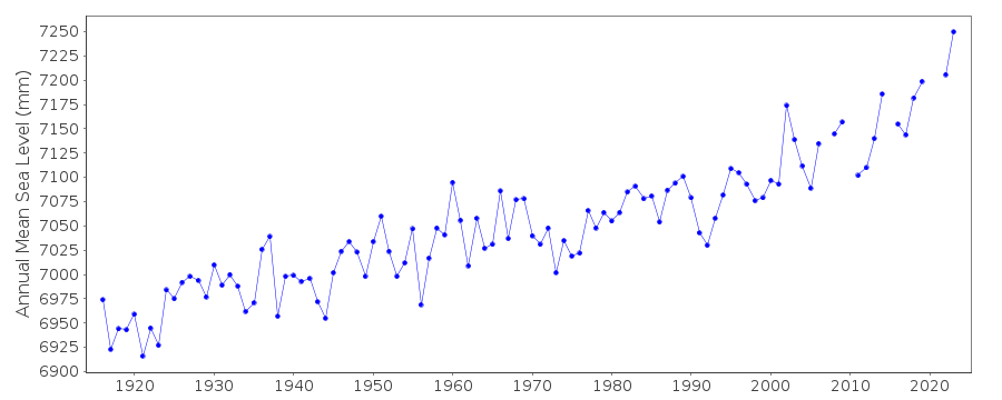
Station Information
| Station ID: | 202 |
| Latitude: | 50.103 |
| Longitude: | -5.542833 |
| GLOSS ID: | 241 |
| Coastline code: | 170 |
| Station code: | 161 |
| Country: | UNITED KINGDOM |
| Time span of data: | 1915 – 2024 |
| Completeness (%): | 98 |
| Link to ellipsoid: | Available |
| Date of last update: | 19 Feb 2025 |
| Green Arrow: | Current Station |
| Yellow Marker: | Neighbouring RLR Station |
| Red Marker: | Neighbouring Metric Station |
Please note: In many cases, the station position in our database is accurate to only one minute. Thus, the tide gauge may not appear to be on the coast.
Tide Gauge Data
Additional Data Sources (guide to additional data sources)
Nearby GNSS Stations from SONEL: NEWLNearby Real Time Stations from VLIZ: newl2, newl3
Fast Delivery Data from UHSLC station 294: hourly and daily
Research Quality Data from UHSLC station 294: hourly and daily
Station Documentation
Link to RLR information.Documentation added 1991-06-11
Newlyn 170/161 RLR(1964) is 11.7m below TGBM SW4676 2855Documentation added 1994-07-21
Newlyn had a stilling well gauge operated by the Ordnance Survey until 1981. In 1981 an Aanderaa presure system gauge was installed,replaced in September 1983 by an "A Class" bubbler.Documentation added 1994-09-21
Data processed by Ordnance Survey until 1981Documentation added 2001-01-02
Recent work on vertical land movements in the UK can be found from the University of Nottingham web site:http://ukcogr.iessg.nottingham.ac.uk/~eosi/Documentation added 2014-07-03
TGI visited the site on 22.10.2013. During processing the data for November was found to be ~40mm high.Documentation added 2015-05-18
There were problems with loss of pressure at the end of February and September 2014. TGI were at site 30.09.14 their report indicates that the gauge needs to be totally re-furbished.Data Authority
Environment AgencyHorizon House
Deanery Road
BS1 5AH
Bristol

![]()
![]()
![]()
