Data
- Obtaining
- Supplying
- High-Frequency
- Bottom Pressure Records
- Other Long Records
- GLOSS/ODINAFRICA Calibration Data
Donate
Donate to PSMSL
Data Notes
- Individual Station Data and Plot Notes
- Referencing the Data Set
- PSMSL Help File
- 2010 Changes to the PSMSL Data Files
Extracted from Database
06 Apr 2026
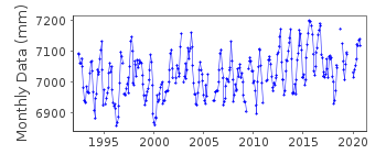
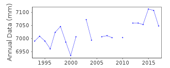
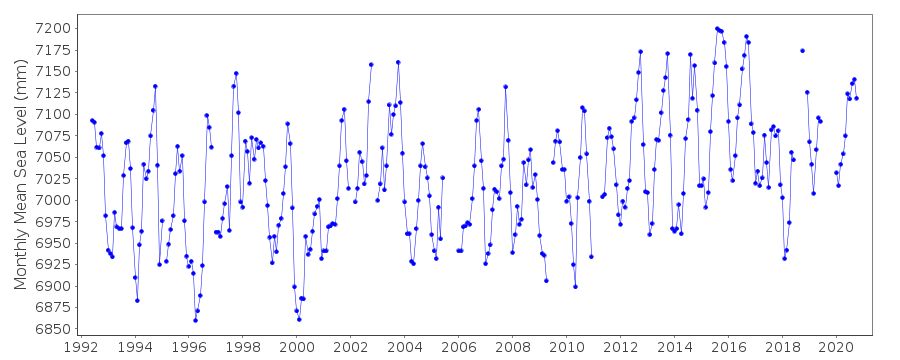
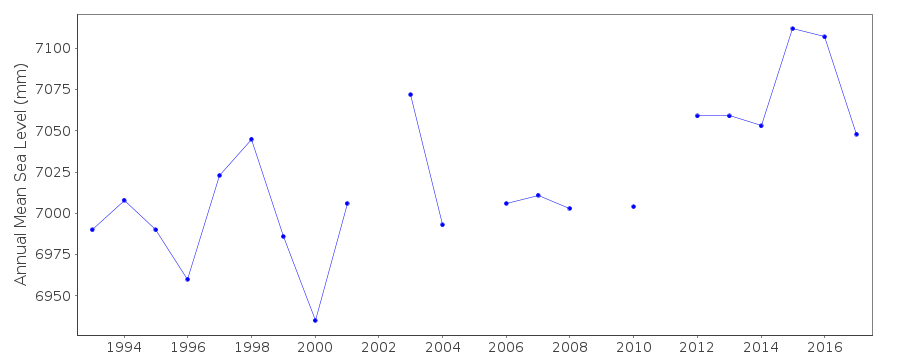
Station Information
| Station ID: | 1910 |
| Latitude: | 19.833333 |
| Longitude: | -77.733333 |
| Coastline code: | 930 |
| Station code: | 91 |
| Country: | CUBA |
| Time span of data: | 1992 – 2024 |
| Completeness (%): | 89 |
| Date of last update: | 18 Jul 2025 |
| Green Arrow: | Current Station |
| Yellow Marker: | Neighbouring RLR Station |
| Red Marker: | Neighbouring Metric Station |
Please note: In many cases, the station position in our database is accurate to only one minute. Thus, the tide gauge may not appear to be on the coast.
Tide Gauge Data
Station Documentation
Link to RLR information.Documentation added 2010-08-26
Cabo Cruz has been made RLR.Both the BM ICH_A and TGZ refer to the Geodesic National Datum (GND). Data is referred to TGZ. BM ICH-A is 2.666m above GND while TGZ is -0.88m below GND. RLR factor is 5.054mDocumentation added 2016-03-03
To reflect the fact that the monthly means supplied refer to TGZ and not GND the RLR diagram has been redrawn. As a result the RLRFAC has changed fron 5.054m to 5.954m. RLR (2008) is now 9.5m below TGBM ICH-ADocumentation added 2016-06-29
Information received from Cuba confirms that the tide gauge sensor since 1992 is a float recording hourly.Data Authority
Cuban National Tidal ServiceCalle 4 No. 304, E/3 Y 3-a
Playa
Cuidad Habana

![]()
![]()
![]()
