Data
- Obtaining
- Supplying
- High-Frequency
- Bottom Pressure Records
- Other Long Records
- GLOSS/ODINAFRICA Calibration Data
Donate
Donate to PSMSL
Data Notes
- Individual Station Data and Plot Notes
- Referencing the Data Set
- PSMSL Help File
- 2010 Changes to the PSMSL Data Files
Extracted from Database
20 Jul 2026
Station Information
| Station ID: | 1850 |
| Latitude: | -54.816667 |
| Longitude: | -68.216667 |
| GLOSS ID: | 181 |
| Coastline code: | 860 |
| Station code: | 3 |
| Country: | ARGENTINA |
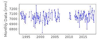
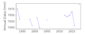
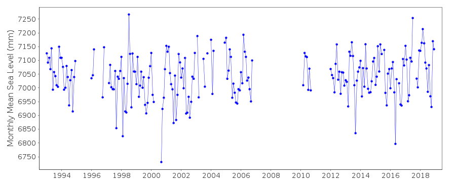
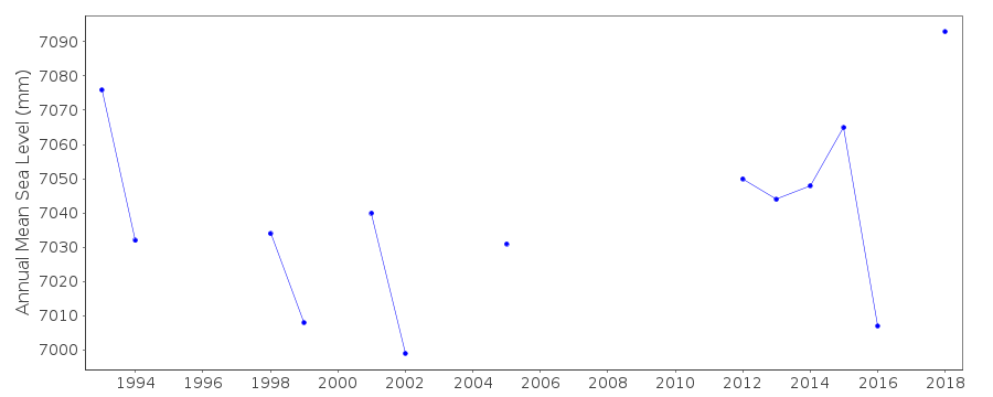
| Time span of data: | 1993 – 2018 |
| Completeness (%): | 68 |
| Date of last update: | 02 Mar 2023 |
| Green Arrow: | Current Station |
| Yellow Marker: | Neighbouring RLR Station |
| Red Marker: | Neighbouring Metric Station |
Please note: In many cases, the station position in our database is accurate to only one minute. Thus, the tide gauge may not appear to be on the coast.
Tide Gauge Data
Additional Data Sources (guide to additional data sources)
Nearby Real Time Stations from VLIZ: ushuFast Delivery Data from UHSLC station 600: hourly and daily
Research Quality Data from UHSLC station 600: hourly and daily
Station Documentation
Link to RLR information.Documentation added 2000-03-10
data for January 1996-December 1999 received via WOCE databank (Hawaii)and has had preliminary quality control processing only
Documentation added 2010-11-24
Dataset 1996-2006 supplied by UHSLC. Previously the authority was said to be NOAA. But referring to previous comments the authority on the database was changed to UHSLC.Documentation added 2015-10-21
After receiving the latest JASL data the complete UHSLC dataset 1996-2014 has been added to the database. Several data points have been added to the previous JASL version.Data Authority
University of Hawaii Sea Level CenterDepartment of Oceanography Division of Natural Sciences
1000 Pope Road
Honolulu
Hawaii 96822

![]()
![]()
![]()
