Data
- Obtaining
- Supplying
- High-Frequency
- Bottom Pressure Records
- Other Long Records
- GLOSS/ODINAFRICA Calibration Data
Donate
Donate to PSMSL
Data Notes
- Individual Station Data and Plot Notes
- Referencing the Data Set
- PSMSL Help File
- 2010 Changes to the PSMSL Data Files
Extracted from Database
02 Mar 2026
Station Information
| Station ID: | 1849 |
| Latitude: | -49.351501 |
| Longitude: | 70.255501 |
| GLOSS ID: | 23 |
| Coastline code: | 434 |
| Station code: | 1 |
| Country: | FRENCH SOUTHERN TERRITORIES |
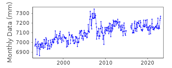
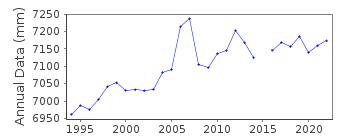
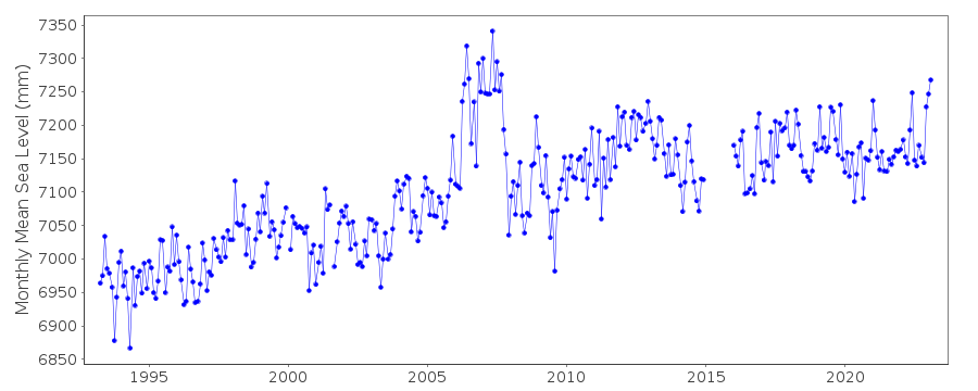
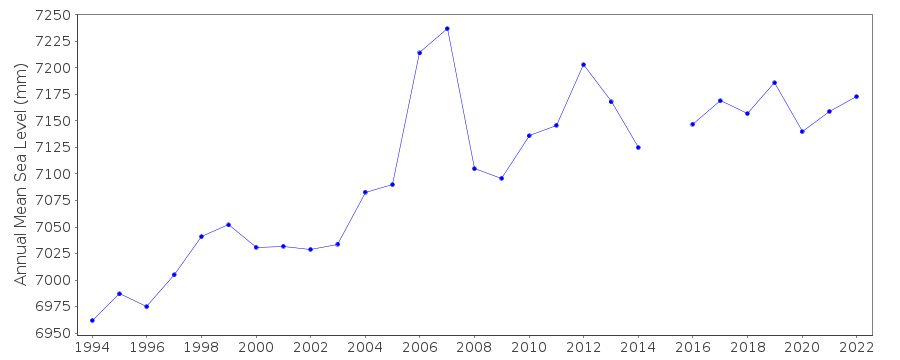
| Time span of data: | 1993 – 2023 |
| Completeness (%): | 93 |
| Link to ellipsoid: | Available |
| Date of last update: | 20 Feb 2026 |
| Green Arrow: | Current Station |
| Yellow Marker: | Neighbouring RLR Station |
| Red Marker: | Neighbouring Metric Station |
Please note: In many cases, the station position in our database is accurate to only one minute. Thus, the tide gauge may not appear to be on the coast.
Tide Gauge Data
Additional Data Sources (guide to additional data sources)
Nearby GNSS Stations from SONEL: KERG, KETG, KRGGNearby Real Time Stations from VLIZ: kerg, kerg2
Fast Delivery Data from UHSLC station 180: hourly and daily
Research Quality Data from UHSLC station 180: hourly and daily
Station Documentation
Link to RLR information.Documentation added 2001-10-17
The gauge is an Aanderaa WLR7 tide recorder. The gauge is installed along the wharf of Port-aux-France. This bottom pressure sensor is at the base of a stilling well which is used to filter waves. The recorder is triggered by a central unit where the barometric pressure is measured at the same time.Documentation added 2001-11-05
Monthly means fully corrected for air pressure drift effects have been used from the French operators.Documentation added 2010-09-22
Kerguelen is part of the French Rosame network. Data for April 1993-May 2010 was downloaded from ftp://ftp.legos.obs-mip.fr/pub/soa/niveau_mer/rosame/. Data for May 1993- Dec 2000 was already in the database the new data appears to be a month out of phase with the old but agrees with the Hawaii data. Previous data has been stored.Documentation added 2014-02-26
Laurent Testut for LEGOS the authority responsible for Kerguelen suspects that the data displayed on the SONEL website is infact the unreferenced data. He is going to investigate the situation and confirm.Documentation added 2014-09-24
Using values from the SONEL website the latitude and longitude for Kerguelen has been revised.Documentation added 2017-04-04
Using information from both SHOM and SONEL Kerguelen has been made RLR. Primary benchmark is B under the SHOM id and KERGU-13 under the SONEL id. Primary benchmark is 3.072m above the gauge datum Zero Hydrographic.Documentation added 2025-07-15
Updated the whole dataset to ensure they include all the historical data recovered recently by SHOM and the calculated monthly and annual means match those distributed by SONEL.Data Authority
SHOM13 rue de Chatelier
29200 BREST

![]()
![]()
![]()
