Data
- Obtaining
- Supplying
- High-Frequency
- Bottom Pressure Records
- Other Long Records
- GLOSS/ODINAFRICA Calibration Data
Donate
Donate to PSMSL
Data Notes
- Individual Station Data and Plot Notes
- Referencing the Data Set
- PSMSL Help File
- 2010 Changes to the PSMSL Data Files
Extracted from Database
11 Mar 2024
Station Information
| Station ID: | 1818 |
| Latitude: | 19.066667 |
| Longitude: | -104.3 |
| GLOSS ID: | 163 |
| Coastline code: | 830 |
| Station code: | 72 |
| Country: | MEXICO |
| Time span of data: | 1992 – 2013 |
| Completeness (%): | 83 |
| Date of last update: | 28 Feb 2018 |
| Green Arrow: | Current Station |
| Yellow Marker: | Neighbouring RLR Station |
| Red Marker: | Neighbouring Metric Station |
Please note: In many cases, the station position in our database is accurate to only one minute. Thus, the tide gauge may not appear to be on the coast.
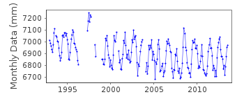
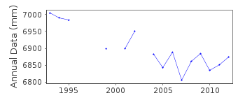
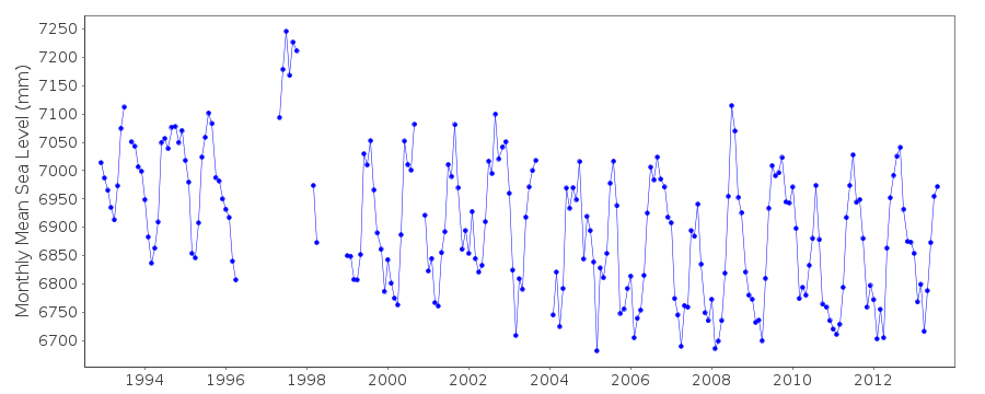
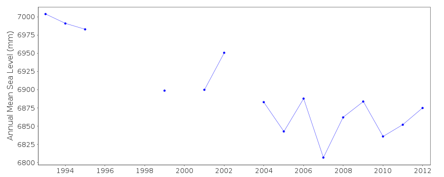
Tide Gauge Data
Additional Data Sources (guide to additional data sources)
Nearby GNSS Stations from SONEL: MNZO, TNMZ, UCOM, MANZ, MZNCNearby Real Time Stations from VLIZ: mnza
Fast Delivery Data from UHSLC station 395: hourly and daily
Research Quality Data from UHSLC station 395: hourly and daily
Station Documentation
Link to RLR information.Documentation added 1997-01-30
Large earthquake offshore of Mexico about 19 degrees North on 9 October 1995 with large tsunami generated. See article by A.E.Filonov in EOS, 78(3), 1997.Documentation added 2002-10-24
Manzanillo 2: Data from 1996-supplied by University of Hawaii. Metric data adjusted by 40ft from those of originator to be consistent with UHDocumentation added 2004-12-07
Manzanillo 2 830/072 RLR(1995) is 9.9m below BM DGOM 9501 A 1992Documentation added 2010-11-22
The complete dataset 1992-2003 has been supplied by UHSLC. These data values were checked against existing values and then the whole dataset was entered onto the database. RLR remains 2.986m.Documentation added 2015-09-23
Using the complete dataset supplied by UHSLC this data series has been re-loaded through to 2012. Several data points have been added/revised.Data Authority
University of HawaiiDepartment of Oceanography Division of Natural Sciences
1000 Pope Road
Honolulu
Hawaii 96822

![]()
![]()
![]()
