Data
- Obtaining
- Supplying
- High-Frequency
- Bottom Pressure Records
- Other Long Records
- GLOSS/ODINAFRICA Calibration Data
Donate
Donate to PSMSL
Data Notes
- Individual Station Data and Plot Notes
- Referencing the Data Set
- PSMSL Help File
- 2010 Changes to the PSMSL Data Files
Extracted from Database
24 Nov 2025
Station Information
| Station ID: | 1796 |
| Latitude: | -51.692358 |
| Longitude: | -57.820514 |
| GLOSS ID: | 305 |
| Coastline code: | 863 |
| Station code: | 2 |
| Country: | FALKLAND ISLANDS (MALVINAS) |
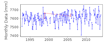
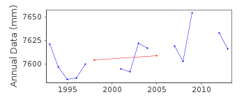
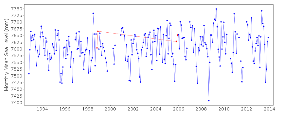
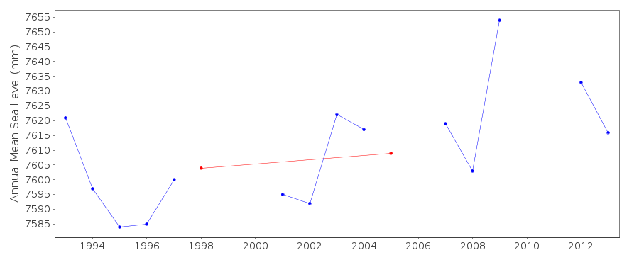
| Time span of data: | 1992 – 2013 |
| Completeness (%): | 88 |
| Date of last update: | 13 May 2022 |
| Green Arrow: | Current Station |
| Yellow Marker: | Neighbouring RLR Station |
| Red Marker: | Neighbouring Metric Station |
Please note: In many cases, the station position in our database is accurate to only one minute. Thus, the tide gauge may not appear to be on the coast.
Tide Gauge Data
Additional Data Sources (guide to additional data sources)
Nearby GNSS Stations from SONEL: FALKNearby Real Time Stations from VLIZ: stan2
Station Documentation
Link to RLR information.Documentation added 1999-06-04
Values for 1994 were revised on 4 June 1999Documentation added 1999-12-06
The RLR datums for both Stanley I (863/001) and Stanley II (863/002)have been set to be 10.7 m below benchmark A which is the same as 12.83 m below
the PWD Office BM. The two RLR series can be combined if required
although there is a large passage of time between them.
Documentation added 2005-09-20
Sea level changes at Port Stanley are discussed byWoodworth, P.L., Pugh, D.T., Meredith, M.P. and Blackman, D.L. 2005.
Sea level changes at Port Stanley, Falkland Islands. Journal
of Geophysical Research, Vol. 110, C06013, doi:10.1029/2004JC002648.
Documentation added 2013-12-19
All data from October 1992 onwards were obtained from various B gauges (a form of accurate pressure tide gauge) located at the east end of Stanley harbour. However, data for October 2008 - April 2012 were obtained from a Kalesto radar tide gauge installed at the same location.Documentation added 2022-05-09
RLR factors for November and December 1998, and November and December 2005 were changed incorrectly in 2014: this change has been reverted. Maintenance at the site was carried out in both October 1998 and 2005, and in both cases the datum was changed. However, at the time the PSMSL database could only accommodate one RLR factor per year, so the heights for the remainder of the year were adjusted to the original datum.In 2014 the database had been updated to allow RLR factors to be applied to each month, and on reviewing the site metadata we applied the new datum to the November and December values in both years, thus erroneously applying the adjustment for the datum shift twice.
We've reverted the change back to the original scheme applying the datum shift at the end of the year to preserve the data as supplied at the time. Note however the labels in the RLR diagram still refer to a datum shift in November to match maintenance records.
Data Authority
British Oceanographic Data CentreNational Oceanography Centre
Joseph Proudman Building, 6 Brownlow Street
Liverpool
L3 5DA

![]()
![]()
![]()
