Data
- Obtaining
- Supplying
- High-Frequency
- Bottom Pressure Records
- Other Long Records
- GLOSS/ODINAFRICA Calibration Data
Donate
Donate to PSMSL
Data Notes
- Individual Station Data and Plot Notes
- Referencing the Data Set
- PSMSL Help File
- 2010 Changes to the PSMSL Data Files
Extracted from Database
26 Jan 2026
Station Information
| Station ID: | 1795 |
| Latitude: | 49.183333 |
| Longitude: | -2.116667 |
| Coastline code: | 180 |
| Station code: | 2 |
| Country: | JERSEY |
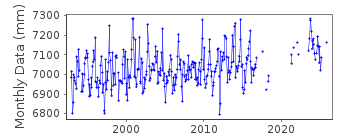
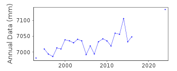
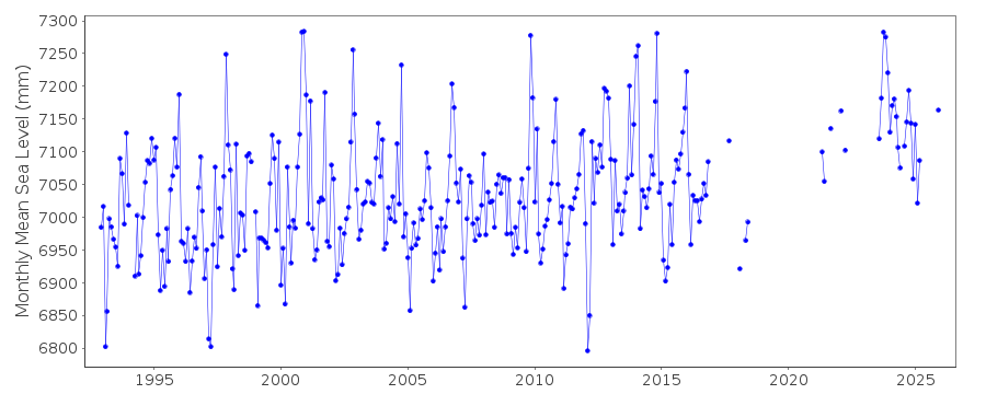
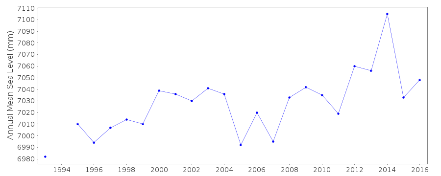
| Time span of data: | 1992 – 2024 |
| Completeness (%): | 78 |
| Date of last update: | 20 Feb 2025 |
| Green Arrow: | Current Station |
| Yellow Marker: | Neighbouring RLR Station |
| Red Marker: | Neighbouring Metric Station |
Please note: In many cases, the station position in our database is accurate to only one minute. Thus, the tide gauge may not appear to be on the coast.
Tide Gauge Data
Additional Data Sources (guide to additional data sources)
Nearby Real Time Stations from VLIZ: jersStation Documentation
Link to RLR information.Documentation added 1994-07-20
Gauge is an "A Class" bubbler maintained by POL.Documentation added 1998-06-02
RLR redefined, 2 June 1997Documentation added 2000-04-20
Datums of gauge readjusted 5th June 1997Documentation added 2000-04-25
St. Helier 2 180/002 RLR(1995) is 14.7m below TGBM 6465 4764Data Authority
Environment AgencyHorizon House
Deanery Road
BS1 5AH
Bristol

![]()
![]()
![]()
