Data
- Obtaining
- Supplying
- High-Frequency
- Bottom Pressure Records
- Other Long Records
- GLOSS/ODINAFRICA Calibration Data
Donate
Donate to PSMSL
Data Notes
- Individual Station Data and Plot Notes
- Referencing the Data Set
- PSMSL Help File
- 2010 Changes to the PSMSL Data Files
Extracted from Database
20 Jul 2026
Station Information
| Station ID: | 1772 |
| Latitude: | 55.627583 |
| Longitude: | -6.189917 |
| Coastline code: | 170 |
| Station code: | 244 |
| Country: | UNITED KINGDOM |
| Time span of data: | 1991 – 2011 |
| Completeness (%): | 94 |
| Date of last update: | 19 Feb 2026 |
| Green Arrow: | Current Station |
| Yellow Marker: | Neighbouring RLR Station |
| Red Marker: | Neighbouring Metric Station |
Please note: In many cases, the station position in our database is accurate to only one minute. Thus, the tide gauge may not appear to be on the coast.
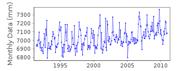
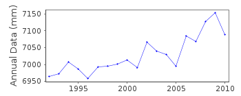
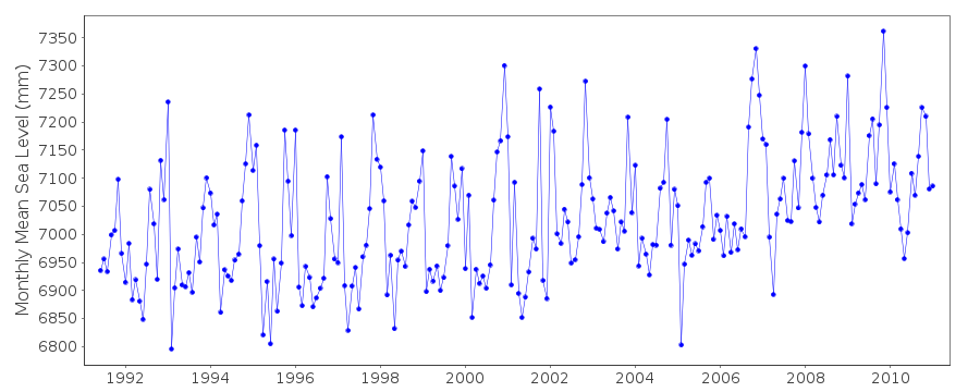
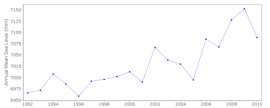
Tide Gauge Data
Station Documentation
Link to RLR information.Documentation added 1994-07-20
Gauge is an "A Class" bubbler maintained by POL.Documentation added 2000-04-25
Islay (Port Ellen) 170/244 RLR(1993) is 9.4m below TGBM NR 3635 4507Documentation added 2001-01-02
Recent work on vertical land movements in the UK can be found fromthe University of Nottingham web site:
http://ukcogr.iessg.nottingham.ac.uk/~eosi/
Documentation added 2009-07-30
The tide gauge at Port Ellen is sinking.This is because the quayside has been gradually
collapsing since 2005. The TGI are aware of the
problem and intend to re-site the gauge.
Documentation added 2009-10-19
The measuring system at Port Ellen has had to be relocateddue to the harbour wall subsiding. The new location is 2m
from the original location and the measuring system is
mounted on steel piling. A mid-tide sensor has also been
added and levelling completed. Values are
Full tide sensor -570mm ACD
Mid-tide sensor +475mm ACD
All other parameters remain the same.
Documentation added 2014-07-02
Last data avalable for Islay is January 2011. The tide gauge has been removed from the network due to harbour re-development. Work on a replacement installation has begun and is ongoing.Data Authority
Environment AgencyHorizon House
Deanery Road
BS1 5AH
Bristol

![]()
![]()
![]()
