Data
- Obtaining
- Supplying
- High-Frequency
- Bottom Pressure Records
- Other Long Records
- GLOSS/ODINAFRICA Calibration Data
Donate
Donate to PSMSL
Data Notes
- Individual Station Data and Plot Notes
- Referencing the Data Set
- PSMSL Help File
- 2010 Changes to the PSMSL Data Files
Extracted from Database
08 Dec 2025
Station Information
| Station ID: | 1759 |
| Latitude: | 59.036046 |
| Longitude: | 10.949769 |
| Coastline code: | 40 |
| Station code: | 341 |
| Country: | NORWAY |
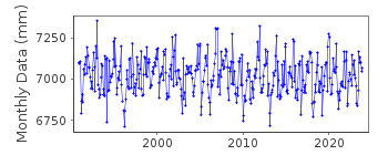
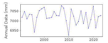
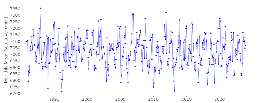
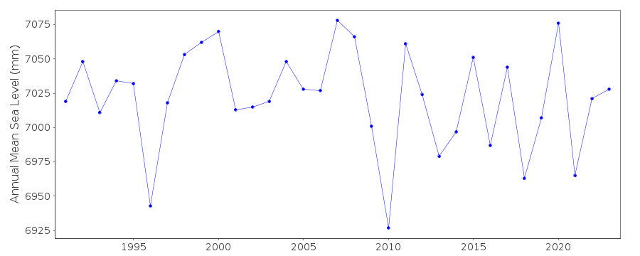
| Time span of data: | 1990 – 2024 |
| Completeness (%): | 97 |
| Date of last update: | 09 Jan 2025 |
| Green Arrow: | Current Station |
| Yellow Marker: | Neighbouring RLR Station |
| Red Marker: | Neighbouring Metric Station |
Please note: In many cases, the station position in our database is accurate to only one minute. Thus, the tide gauge may not appear to be on the coast.
Tide Gauge Data
Additional Data Sources (guide to additional data sources)
Nearby Real Time Stations from VLIZ: vikeStation Documentation
Link to RLR information.Documentation added 1995-03-30
tide gauge network modernised, new equipment installed in 1990Documentation added 2000-04-25
Viker 040/341 RLR(1992) is 10.3m below TGBM (G37 N111)Documentation added 2012-09-05
For information of sea level rise along the Norwegian coast, see paper " Contributions to sea level variability along the Norwegian coast for 1960-2010 "by K. Richter, J.E.O. Nilsen and H. Drange.Documentation added 2015-11-17
The PSMSL has been notified by the Norwegian Authority that the tide gauge at Viker is sinking. The rate of sinking has been confirmed as 0.30mm/year. with the supply of the 2014 sea level data a revised dataset beginning January 1991 has been supplied. Future data will be supplied with the correction applied.Data Authority
Norwegian Mapping AuthorityHydrographic Service
Po. Box 60
4001 Stavanger

![]()
![]()
![]()
