Data
- Obtaining
- Supplying
- High-Frequency
- Bottom Pressure Records
- Other Long Records
- GLOSS/ODINAFRICA Calibration Data
Donate
Donate to PSMSL
Data Notes
- Individual Station Data and Plot Notes
- Referencing the Data Set
- PSMSL Help File
- 2010 Changes to the PSMSL Data Files
Extracted from Database
02 Mar 2026
Station Information
| Station ID: | 1736 |
| Latitude: | -2.566667 |
| Longitude: | -44.383333 |
| GLOSS ID: | 200 |
| Coastline code: | 874 |
| Station code: | 155 |
| Country: | BRAZIL |
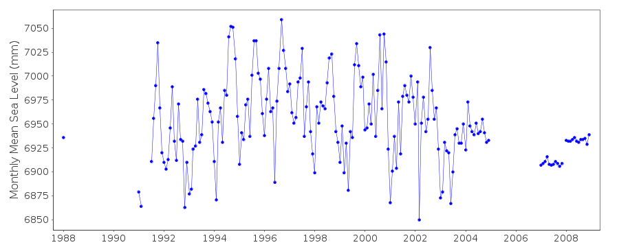
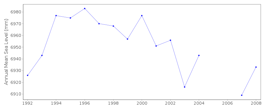
| Time span of data: | 1988 – 2008 |
| Completeness (%): | 75 |
| Date of last update: | 14 Nov 2017 |
| Green Arrow: | Current Station |
| Yellow Marker: | Neighbouring RLR Station |
| Red Marker: | Neighbouring Metric Station |
Please note: In many cases, the station position in our database is accurate to only one minute. Thus, the tide gauge may not appear to be on the coast.
Tide Gauge Data
Additional Data Sources (guide to additional data sources)
Research Quality Data from UHSLC station 715: hourly and dailyStation Documentation
Link to RLR information.Documentation added 2006-07-07
Data are received from the University of Hawaii Sea Level CenterDocumentation added 2008-10-09
Monthly mean sea level data values for 2004supplied by Marcelo these differ slightly from those supplied by UH.
UH values printed off and stored in file. Marcelos values
entered onto the database. In future it is hoped the data
will be accessed directly from Marcelo.
Data Authority
Director of Hydrography and NaviagationRua Barao de Jaceguai,
S/No - Ponta da Armacao

![]()
![]()
![]()
