Data
- Obtaining
- Supplying
- High-Frequency
- Bottom Pressure Records
- Other Long Records
- GLOSS/ODINAFRICA Calibration Data
Donate
Donate to PSMSL
Data Notes
- Individual Station Data and Plot Notes
- Referencing the Data Set
- PSMSL Help File
- 2010 Changes to the PSMSL Data Files
Extracted from Database
11 Mar 2024
Station Information
| Station ID: | 1711 |
| Latitude: | 12.333333 |
| Longitude: | 121.083333 |
| Coastline code: | 660 |
| Station code: | 2 |
| Country: | PHILIPPINES |
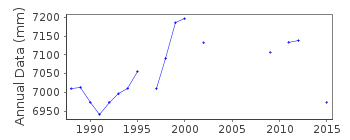
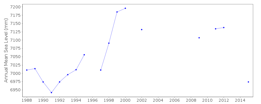
| Time span of RLR data: | 1988 – 2022 |
| RLR completeness (%): | 69 |
| Time span of metric data: | 1987 – 2022 |
| Metric completeness (%): | 70 |
| Date of last update: | 13 Jun 2023 |
| Green Arrow: | Current Station |
| Yellow Marker: | Neighbouring RLR Station |
| Red Marker: | Neighbouring Metric Station |
Please note: In many cases, the station position in our database is accurate to only one minute. Thus, the tide gauge may not appear to be on the coast.
Tide Gauge Data
Station Documentation
Link to RLR information.Documentation added 1991-06-11
San Jose 660/002 RLR(1989) is 8.2m below BM3Documentation added 1999-03-30
gauge type = Leupold & Stevens/EMS-16Documentation added 2010-10-06
Looking at the dataset as a whole. There is no datum information for 1987 data so this has to remain 'Metric'. From 1988-1993 Benchmark is BM3 2.898m above Datum reference TSO1986 RLRFAC is 5.302m. 1994-1995 benchmark and datum remain the same but relationship is adjusted to 2.924m with RLRFAC 5.276m. 1996-1997 benchmark is still BM3 and datum TSO1986 but relationship is adjusted again to 2.952 with RLRFAC 5.248m. 1998-2000 Benchmark BM3 and datum still TSO1986 relationship reverts to 2.924m RLRFAC again 5.276m. 2001-2002 Benchmark changes to BM 4A 3.775m above datum TSO1986. Gauge is re-instated 2009 benchmark is BM2 3.166m above TSO1986 The benchmark BM2 from the re-instated gauge was used as the Primary benchmark in the RLR diagramThe additional benchmarks have also been included.
Documentation added 2012-02-27
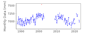
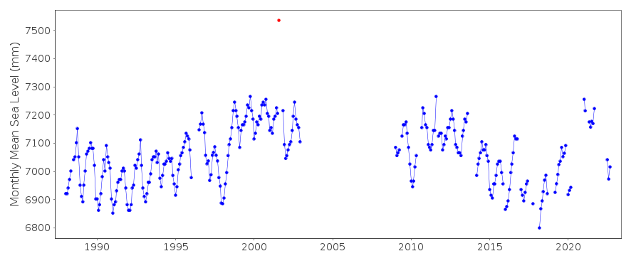
The data point for San Jose for August 2001 has been flagged as suspect. However, it is extremely difficult to determine whether spikes are real or not in the Philippine stations as there is rarely a station close enough to 'buddy check'it with. Gauge type is THALIMEDESDocumentation added 2018-02-07
Following a query revised data values have been supplied for 2016 data.Data Authority
National Mapping and Resource Information AuthorityHydrography Department
421 Barraca St,
San Nicolas 1010
Manila

![]()
![]()
![]()
