Data
- Obtaining
- Supplying
- High-Frequency
- Bottom Pressure Records
- Other Long Records
- GLOSS/ODINAFRICA Calibration Data
Donate
Donate to PSMSL
Data Notes
- Individual Station Data and Plot Notes
- Referencing the Data Set
- PSMSL Help File
- 2010 Changes to the PSMSL Data Files
Extracted from Database
11 Mar 2024
Station Information
| Station ID: | 1496 |
| Latitude: | 22.216667 |
| Longitude: | 91.05 |
| GLOSS ID: | 36 |
| Coastline code: | 510 |
| Station code: | 8 |
| Country: | BANGLADESH |
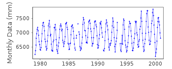
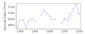
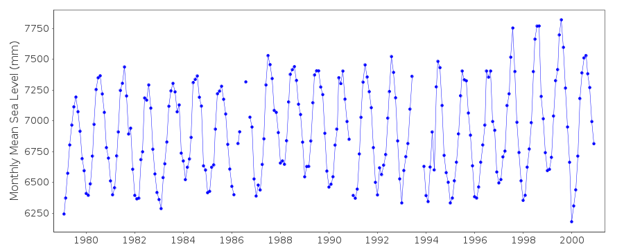
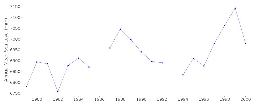
| Time span of data: | 1979 – 2000 |
| Completeness (%): | 96 |
| Date of last update: | 17 Jun 2013 |
| Green Arrow: | Current Station |
| Yellow Marker: | Neighbouring RLR Station |
| Red Marker: | Neighbouring Metric Station |
Please note: In many cases, the station position in our database is accurate to only one minute. Thus, the tide gauge may not appear to be on the coast.
Tide Gauge Data
Additional Data Sources (guide to additional data sources)
Research Quality Data from UHSLC station 138: hourly and dailyStation Documentation
Link to RLR information.Documentation added 1993-11-15
DATA RECEIVED FROM TOGA OFFICEDocumentation added 1996-10-15
float and well type gauge (Munro)Documentation added 1999-08-27
data for 1979 and 1995-96 received directly from authority G5Documentation added 2013-06-17
The RLR diagram for Charchanga has been revised. Previously rlrfac adjustments were made 1980-1981 and 1982-1985. However, when the PSMSL data holdings were compared with the UHSLC data anomalies were found. As a result just one rlrfac of 4.804m has been applied to the complete dataset.Data Authority
Bangladesh Inland Water, Department of HydrographyTransport Authority
141-143 Motijheel C/a
Dhaka 1000

![]()
![]()
![]()
