Data
- Obtaining
- Supplying
- High-Frequency
- Bottom Pressure Records
- Other Long Records
- GLOSS/ODINAFRICA Calibration Data
Donate
Donate to PSMSL
Data Notes
- Individual Station Data and Plot Notes
- Referencing the Data Set
- PSMSL Help File
- 2010 Changes to the PSMSL Data Files
Extracted from Database
08 Dec 2025
Station Information
| Station ID: | 1462 |
| Latitude: | -27.15 |
| Longitude: | -109.45 |
| GLOSS ID: | 137 |
| Coastline code: | 810 |
| Station code: | 2 |
| Country: | CHILE |
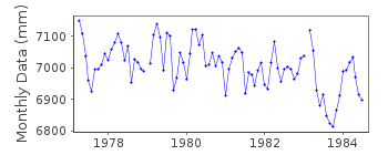
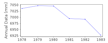
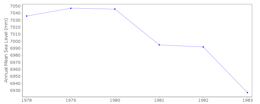
| Time span of data: | 1977 – 1984 |
| Completeness (%): | 90 |
| Date of last update: | 11 Sep 1990 |
| Green Arrow: | Current Station |
| Yellow Marker: | Neighbouring RLR Station |
| Red Marker: | Neighbouring Metric Station |
Please note: In many cases, the station position in our database is accurate to only one minute. Thus, the tide gauge may not appear to be on the coast.
Tide Gauge Data
Additional Data Sources (guide to additional data sources)
Nearby GNSS Stations from SONEL: EISL, ISPANearby Real Time Stations from VLIZ: east2, east
Fast Delivery Data from UHSLC station 22: hourly and daily
Research Quality Data from UHSLC station 22: hourly and daily
Station Documentation
Link to RLR information.Documentation added 1991-06-11
Easter Island-D 810/002 RLR(1982) is 8.7m below BMUH-1Documentation added 1993-07-12
Easter Island-D 810/002 RLR(1982) is 8.7m below BMUH-1Easter Island -D is an historic station last data 1984
Data Authority
University of Hawaii Sea Level CenterDepartment of Oceanography Division of Natural Sciences
1000 Pope Road
Honolulu
Hawaii 96822

![]()
![]()
![]()
