Data
- Obtaining
- Supplying
- High-Frequency
- Bottom Pressure Records
- Other Long Records
- GLOSS/ODINAFRICA Calibration Data
Donate
Donate to PSMSL
Data Notes
- Individual Station Data and Plot Notes
- Referencing the Data Set
- PSMSL Help File
- 2010 Changes to the PSMSL Data Files
Extracted from Database
09 Feb 2026
Station Information
| Station ID: | 146 |
| Latitude: | 54.6 |
| Longitude: | 18.8 |
| Coastline code: | 110 |
| Station code: | 42 |
| Country: | POLAND |
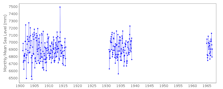
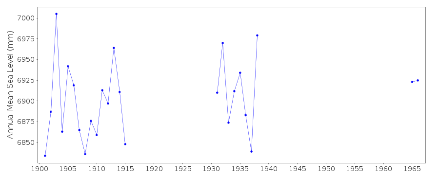
| Time span of RLR data: | 1901 – 1966 |
| RLR completeness (%): | 38 |
| Time span of metric data: | 1901 – 1970 |
| Metric completeness (%): | 41 |
| Date of last update: | 30 Mar 2016 |
| Green Arrow: | Current Station |
| Yellow Marker: | Neighbouring RLR Station |
| Red Marker: | Neighbouring Metric Station |
Please note: In many cases, the station position in our database is accurate to only one minute. Thus, the tide gauge may not appear to be on the coast.
Tide Gauge Data
Station Documentation
Link to RLR information.Documentation - date unknown
1901-1915,1936 No. of readings per day unknown1931-1935,1937-1938 Values based on 1 reading per day
Documentation added 1991-06-11
Hel 110/042 RLR(1938) is 10.2m below BM ChurchDocumentation added 1993-07-29
Large value in December 1913 common to more than one station (see also Liepaja, ID 26). Hel is an historic station last data 1966Documentation added 2016-03-30
Data flags removed for 1913 - as mentioned above, the extreme value for December 1913 also appears in nearby records.Data Authority
Inst. for Meteorology and Water ManagementMaritime Branch
Ul. Waszyngtona 42
PL-81-342 Gdynia

![]()
![]()
![]()
